Carlson Software: Student Version

Answering a need that’s been out there for some time, Carlson has recently announced the availability of a “Student Version” of their products.

From the announcement in the American Surveyor magazine:

Carlson Software is offering civil engineering, land surveying and mining students the option of purchasing their own software on which to learn and work at home for $99 for a full academic year. This program is available for fulltime students.

The software that Carlson is offering for this program includes the following:

  • Carlson Civil Suite – Carlson Survey, Carlson Civil, Carlson Hydrology and Carlson GIS in one powerful package.
  • Carlson Survey – now with C&G Survey included is the ultimate office survey software
  • Carlson Takeoff – provides fast and accurate CAD-based estimating, plus essential quantity and quality controls
  • Carlson Mining – the software choice of the U.S. coal mining industry in Underground, Surface and Geology modules

To apply for your Student Version of Carlson Software, you must complete this application and submit it online. Lauren Brown, the Academics Coordinator for Carlson Software, will contact you to complete your purchase.

Carlson Software: In the Classroom

Did you know that there are almost 200 colleges and universities currently participating in Carlson’s Academics Program?

Carlson works simply and simply works – making it the ideal CAD-based software program to learn while in school. Why spend time fighting the peculiarities of a software program when Carlson, rightly, allows students to concentrate on learning the concepts essential to their chosen Surveying, Engineering, Construction or Mining fields?

Learning to use Carlson Software helps improve students’ chances to get jobs after graduation and makes it possible for them to complete projects on their own both during school and after. Because Carlson includes a FREE copy of IntelliCAD with every Carlson license, learning institutions can also use Carlson with IntelliCAD for basic CAD training in other programs such as general design, architectural & mechanical design and many others.

For an annual fee of $650, Carlson Software provides unlimited desktop licensing to qualified colleges and universities. Carlson Software with IntelliCAD allows institutions to stay within their budget while still providing their technical students with the tools they need to be competent and competitive in the marketplace.

Interested in receiving your first year for FREE?

Contact Lauren Brown, Carlson’s Academic Coordinator, at 606.564.5028 and let her know you heard about this offer from “That CAD Girl”.

That CAD Girl is working with Carlson to schedule “Train the Trainer” events for the Summer of 2010. These hands-on, multi-day training events will assist classroom instructors with development of lesson plans and exercises. Events are tentatively being planned for Eastern Tennessee, Ohio, Florida and Oregon. Please contact us at 919.417.8351 or [email protected] to request additional locales.


Export IntelliCAD or AutoCAD DWG files to Google Earth

I’ve recently started using a very cool feature in Carlson Software. The bad thing… it was in the 2009 version and I didn’t even realize it!

I had no idea exporting our DWG files from IntelliCAD or AutoCAD out to Google Earth was so easy.

  1. Download and install Google Earth. You can download it here: http://earth.google.com/
  2. Open any one of your project DWG files that has been positioned at its correct state plane coordinate system.
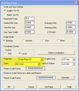
  3. In Carlson, go to Settings –> Drawing Setup and then select the correct Projection and correct Zone for the project site. If you’re not sure of the Projection, try using “State Plane 83”. This will work for most systems.
  4. Next, go to File –> Polyline File –> Write Polyline File. When prompted for “Polyline File Format”, type “G” for Google. You will be prompted to specify a new filename and save location for a “Google Earth File to Write (.kml)”.
  5. You will then be prompted to select the entities that are to be exported out to the .kml file and viewed in Google Earth. After selecting the entities, press Enter. For this exercise, we only want to see the drawing entities in 2D, so press “N” for “No” when prompted to “Use elevation from drawing in Google Earth [Yes/<No>]?”
  6. Finally, you are then prompted “Would you like to display the file in Google Earth now [<Yes>/No]?”. Press “Y” for “Yes”. Google Earth should automatically launch and zoom into the project location.

In the example shown below and pointed out with arrows, notice how closely the new roads and designed turn lanes match up to the existing roadway. Also, you can see the designed graded slopes perfectly avoiding the tank that is to be preserved during construction.
Not too shabby…

This feature is available in all of the Carlson Desktop products: Carlson Civil, Survey, Hydrology, Construction and TakeOff.

Look for a future post on bringing Google Earth surface data into Carlson Software. Hint: It’s easy too!

Originally posted on Carlson Connection by Jennifer Dibona