What is LandXML?

This article originally appeared in the April 2011  issue of Professional Surveyor magazine.

The ability to import and export LandXML data has been around for quite a while, but I still get a lot of curious looks when I mention it in my training classes. So, what is it, and why should you be using it?

What Is LandXML?

LandXML refers to a file format (.xml) containing data that has been generated from a civil engineering or land surveying software program.

If you’re hearing about it for the first time and want to learn more about the uses and acceptance of the LandXML initiative, visit www.landxml.org. According to their page LandXML.org in a Nutshell, “… LandXML.org is committed to providing a non-proprietary data standard (LandXML), driven by an industry consortium of partners.”

Simply put, the easiest way to convert, transfer, and archive data between Civil 3D, Carlson Software, Land Desktop, Eagle Point, TerraModel, and many other programs is to use the Import from LandXML and Export to LandXML functions available in these programs. Additionally, many machine control systems allow you to import LandXML files. I am most familiar with the Carlson and Autodesk families of civil/survey programs, so most examples in this article refer to them.

This may not be current by the time you read this article, but the list of members and participating organizations is at www.landxml.org/org.htm.

Why You Should Use It To Transfer Data

The two key words in the mission statement above are “non-proprietary.” Just as we have multiple proprietary drawing file formats such as .dwg (from Autodesk’s AutoCAD-based programs) and .dgn (from Bentley’s Microstation), the files that store survey and civil data such as points, surfaces, centerlines, and profiles are unique and proprietary to their manufacturer.

For instance, Civil 3D is the survey/civil product for Autodesk. Points and surfaces created in that program are stored inside the .dwg file. If you have Civil 3D and need to share a surface with a consultant or other team member who owns the same version of Civil 3D, you can just send them the .dwg file and they will have full access to the point and surface data. However, if you have Civil 3D and your consultant uses an earlier version of Civil 3D, Land Desktop, or Carlson Software or needs the surface data for machine control, it will not be as simple as just sharing the .dwg file.

Similarly, surfaces created in Carlson Software are saved in a .tin file and points are stored in a .crd (coordinate) file. Anyone using Carlson Software or SurvCE data collectors can load these files in their native format. But, Civil 3D or other survey/civil programs can’t access them directly.

As you probably already know, when you have to pass this data onto someone using a different program, it’s a nightmare! This is where LandXML is a lifesaver.

I like to explain that you use Land-XML files in the same way you used to rely on .dxf files. It’s mostly outdated now, but a .dxf file is a generic drawing file (DXF = Drawing Interchange File) that can be exported from and imported into various CAD programs. Back in the day, AutoCAD wasn’t able to read or import Microstation’s .dgn files and Microstation wasn’t able to read or import AutoCAD .dwg files, but both could export and read .dxf files. To get a Microstation file into AutoCAD, we had to export a .dxf file from Microstation and import it into AutoCAD and vice versa.

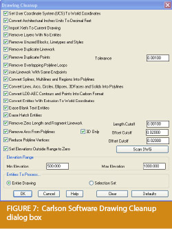
When you export your civil/survey data to an .xml file, it can be opened and read like a text file. Specifically, an .xml file is an .html file that is best viewed through a web browser such as Internet Explorer or Firefox. For instance, when a surface model (TIN) is exported to an .xml file, the X, Y, Z values of each point on the TIN are assigned a number, and then each “face” (triangle) of the TIN is defined by specifying the three corners (Figure 1).

Another benefit of using LandXML to transfer project data is that you can be selective in choosing what project data to include in your .xml file. For instance, in the course of a design project, you may create an existing ground surface, a proposed ground surface for phase one of your project, and a proposed ground surface for phase two. You may have a consultant who needs only your proposed ground surfaces. When you export the .xml file, you have the ability to select only those surfaces that you’d like to add to the file; it’s not necessary to export them all.

For Project Archiving

We’ve all become accustomed to saving archive copies of our drawing files for various purposes, but saving the corresponding project data such as points, point groups, surfaces, centerlines, and profiles is often overlooked. Retrieving the drawing file (.dwg or .dgn) may allow you to recover the linework that represents contours or a profile, but the underlying “surface” is lost unless the project data was also archived.

When archiving your projects at completion or even at submittal time, it is not enough to simply save a copy of the drawing file(s) for the project; you must also save a copy of the project data. At a minimum, the archive should contain the project data in its native format. In the case of Civil 3D, saving your project data in its native format means saving a copy of all .dwg files that store points, surfaces, or other data relating to your project. Saving this project data in its native format is sometimes the easiest method, but it can also create a problem with file storage because the files can become enormous.

This won’t be a surprise, but even if you archive your project data in its native format, I recommend that you consider additional archiving in .xml format. This is the case whether you need to save a progress, submittal, or final archive of your data. No one knows what kind of data files we’ll be using 10 or 20 years down the road, so saving your data in such a generic, text-based format such as .xml files allows for easier retrieval regardless of when you need it.

Note that, like archiving in native format, archiving to an .xml file can also produce very large files. I still believe using the .xml format is advantageous because of the generic nature of the data and having the ability to pick and choose the data you need to archive.

I hope you’ve gotten some clarification on this fantastic tool we’ve all had for years but many of us have not taken advantage of. If you have questions, please don’t hesitate to follow up.

This article originally appeared in the April 2011 issue of Professional Surveyor magazine.


Join Us For A Technology Breakfast – Various Breakfast Spots in North and South Carolina

Starting in April 2011 we will be hosting a “Technology Breakfast” for current and/or prospective Carlson Software and hardware customers.

These events will be held on the 3rd and 4th Friday of each month and will start at 7:30am. Once a month we will meet at the Cracker Barrel at I-40 in Garner, North Carolina. Other events will be held in various locations in North and South Carolina.

Each breakfast and meeting will last for 1-2 hours and will provide an opportunity for us to demonstrate the future direction of Carlson data collection and field hardware. After breakfast, we will retreat to the parking lot for the field demonstration. Some events will also have a classroom component in a conference room at a neighboring hotel.

Technology Breakfasts will be free of charge but pre-registration is required. Call us at 919.417.8351 or email [email protected]. There is a limit of 10 people at each meeting.

The full list and details for Technology Breakfast meetings can be found here.

Apr 22nd Cracker Barrel at I-40 in Garner, North Carolina.
May 13th Cracker Barrel at I-85 in Gastonia North Carolina
May 20th Cracker Barrel at I-40 in Garner, North Carolina
June 17th Cracker Barrel at I-40 in Garner, North Carolina
June 24th Cracker Barrel at I-77 in Columbia, South Carolina

Keep checking our training page for more details about the new hardware or software to be presented at each event and for additional meetings planned for Asheville, Morehead City, Hickory and Wilmington, North Carolina.


Upcoming FREE Webinar

Future Directions of GIS for Surveyors, Engineers & Construction Professionals

Presented by Janet Jackson (GIS Janet) of Intersect and Gary Rosen of Carlson Software

This one hour webinar is intended to de-mystify the world of GIS for surveyors and engineers needing to learn more about this alternate universe.

For the initial part of the presentation by Janet, I’ve asked her to address, briefly, three questions:

  1. Why do surveyors, engineers and construction professionals need to know about GIS? And, how can it help us?
  2. When an RFP (Request for Proposal) has a “GIS Component” requiring a GIS deliverable, what does that mean and what should we look for?
  3. As surveyors, engineers and contractors using Carlson Software, what are some fairly easy “value-added” services we could offer to existing and potential clients to generate new business?

Following Janet’s presentation, Gary Rosen with Carlson Software will discuss the new technology currently in the market from Carlson and what may be coming down the line.

Register for the April 27th Webinar Here


Upcoming Regional Training Classes – Columbus OH, Raleigh NC, Atlanta and Baltimore

After many requests to hold training classes in different areas of the country, I’ve finally managed to schedule a few dates. The classes are 8 hours of hands-on training and seats are limited. Registration deadlines and pre-requisites vary for each class – Click the link below for the class announcement.

Classes include Intro to Survey, Surface Modeling, Least Squares/SurvNet, Quantity Takeoffs and Drawing Prep for Surface Modeling among others.

Call 919.417.8351 or [email protected] to register.


Meet Jeremy Taylor – Now Helping Me Out with Hardware & Data Collection

I’m happy to announce that Jeremy Taylor, PLS of Taylor Land Consultants has agreed to start helping me out with Carlson Software, data collector, GPS and other hardware sales. I asked him if he’d mind pitching his voice higher as he answered the phone:

Having never been a practicing land surveyor, I have not been able to promote or discuss Carlson’s stable of data collection software or hardware as well as I’d like. I have hoped to find someone who knew the products well and could present them well, but was not a salesman. I think Jeremy will be the perfect fit.

He is very well-known and just as well-respected here in the Raleigh NC area and, I believe, will be a great resource for all of us. Like me, Jeremy is a fan of Carlson’s offerings but is more concerned with providing the right solution for our customers rather than simply trying to sell the latest and greatest piece of equipment. Please take a moment to read Jeremy’s Bio here.

If you have questions on SurvCE, Carlson Survey, data collectors or GPS equipment, please feel free to contact Jeremy at (919) 335-3444 or email him at [email protected]. Going forward I think you can expect to see more of a focus on these products including special pricing and field demonstrations.


Picks and Clicks: Conquer Problem Drawings

This article originally appeared in the February 2011  issue of Professional Surveyor magazine.

While working with IntelliCAD, AutoCAD, or any other AutoCAD-based programs, we’ve all encountered the proverbial drawing from “you-know-where” that seems to drive us crazy from start to finish. Here I offer several tips to help you identify problems and conquer your problem drawings. I’ve listed these tips in the order I would apply them.

1 Purge your drawing.

The PURGE command removes any unused layers, linetypes, text styles, shapes (for linetypes and text), and many other items in the drawing.

When you run the purge command once, it will purge those items that are not currently in use and that have no other dependencies. For example, if a particular linetype definition depends on a particular shape, the purge command will delete the linetype definition only on the first pass.

Purging again will now delete the shape because the dependent linetype no longer resides in the drawing. Enabling the option to “Purge nested items” before purging will automatically execute the command repeatedly until all unused and dependent items are gone.

2 Purge remnants of registered applications that have accessed your drawing.

Typing “–PURGE” will execute the command line version of the purge command. This version includes a few options not available from the purge dialog box.

One of the extra options is “Regapps,” which is available only from the command line version of the command. You access it by typing “R” when prompted. This option removes “leftover” data from other programs (registered applications) that have been used to work on the drawing file.

3 Audit the drawing.

The AUDIT command looks for discrepancies between the objects displayed on the screen and the objects’ definitions in the drawing file database. The command then gives you the option of correcting the errors it has found. This command can be executed only while the drawing is open and active.

4 Recover the drawing and all reference files.

The RECOVER command is a more robust version of the audit command and can be used to open drawings that are so corrupt they cannot be opened otherwise.

Starting the recover command prompts you to browse to and select the problem drawing. If the problem drawing is already open and active, recover will prompt you to save changes before reopening the drawing and starting the recovery process.

For drawings that have attached XREFs (external references), use the RECOVERALL command to open and repair the selected drawing plus all dependent XREFs. Note that errors corrected by the audit are not saved back to the XREFs.

5 Block out the drawing contents to a new drawing.

If you suspect a drawing has become corrupt, you can WBLOCK the entire drawing out to another file. After starting the wblock command, set the “Source” option as “Entire Drawing” and provide the location and name for the newly created file.

Note that this command saves only Model Space entities to the new drawing. If needed, use AutoCAD Design Center to transfer layout tabs.

6 Insert the problem drawing as a block into a new drawing.

Using the same principle as above, you can use the INSERT command to bring the Model Space contents of a problem drawing into another drawing. Doing this will reduce or eliminate corruption in the problem drawing.

Make sure to use 0,0,0 as the insertion point and set the rotation angle and scale appropriately.

As with wblock, this command saves only Model Space entities to the new drawing. If needed, use AutoCAD Design Center to transfer Layout tabs.

7 Export drawings from vertical programs to AutoCAD.

Autodesk products such as Land Desktop or Civil 3D create program-specific, proprietary entities such as AEC Contours and AEC Point Objects. These proprietary objects can become corrupt or otherwise create problems when being accessed from standard AutoCAD or another program that doesn’t recognize the proprietary entities.

You can enter the -EXPORTTOAUTOCAD command at the command line to create a new drawing file that strips out the proprietary entities and leaves only standard AutoCAD entities. For instance, a Land Desktop or Civil 3D drawing containing AEC Contour entities will result in elevated polylines with text when exported to Autocad. And a Land Desktop or Civil 3D drawing containing AEC Point entities will result in a block with attributes when exported to AutoCAD.

Note that any AEC Objects will obviously lose their intelligence, but the new drawing can be opened in any version of Autocad.

8 Use DWG TrueView Convert to fix errors and bind XREFs.

DWG TrueView is a free program that you can download from Autodesk’s website. It is most valuable for its ability to convert drawings to earlier versions individually or in bulk. In the Conversion Setup dialog box, you can specify one or more options to clean drawings during the conversion process.

9 Use the Drawing Cleanup command in AutoCAD Map or Carlson Software.

Both AutoCAD Map and Carlson Software provide Drawing Cleanup commands that provide a variety of cleanup tools. In either version, you have the option of performing one or more cleanup tasks on the entire drawing or on only selected entities in the drawing.

Note: Use these commands with caution and apply cleanup options incrementally to avoid making unwanted changes. Also, I recommend making a backup copy of the active drawing before performing this command.

If you use AutoCAD Map, Land Desktop, or Civil 3D, you can access the Drawing Cleanup command from Map ➜ Tools. In Carlson Software, access it from the File menu.

10

I’ve come up with 9 tips that will help you clean up and, maybe, access drawings that have become corrupt. To round out the list and make it an even 10, I’d like to hear from readers to find out what your favorite drawing recovery and cleanup tools are. Please email me at [email protected] and I’ll report in a future column.

This article originally appeared in the February 2011 issue of Professional Surveyor magazine.


Overstock Pricing Specials – Carlson Civil Suite and Survey/Civil Bundles

I’ve decided to try to clear out the Carlson Software stock that I have on my shelf right now. So, while they last, I have a few seats of the Carlson Survey/Carlson Civil 2011 bundles that were available last December and several Civil Suites that I am also selling at 2010 prices.

I’m not permitted to advertise the price, but you can call 919.417.8351 or [email protected] to find out more.

As of January 26th, I have 7 Civil Suites and 3 Survey/Civil bundles available at these prices. Check out our Carlson Pricing page to keep track of how many are left.


January 2011 – Upcoming Training

The classes listed below may be used for 2010 or 2011 NC PDH credit hours:

Seats are limited so call 919.417.8351 or email [email protected] to reserve your seat today.

Please review our Training Policy here.


That CAD Girl – January 2011 Newsletter

Our January 2011 Newsletter can be downloaded HERE


New Carlson Software Pricing

Since the Year-End-Special pricing on Carlson Software has now expired, see our new advertised Carlson Software Pricing here. Please [email protected] or call 919.417.8351 to request our current price sheet (effective 1/1/2011).