In case you missed it, here is our April 2012 Newsletter…
That CAD Girl – April 2012 Newsletter
Thank you to the Richmond AutoCAD Manifest (RAM)
I’d like to thank Art Thomas and the Richmond Virginia AutoCAD User Group for inviting Jeremy and me to demonstrate Carlson Software and data collection last night. Our hour-and-a-half long presentation covered the basic tools and Survey, Civil and GIS specific features of the Carlson products.
The RAM User Group has been active for 20+ years and has a lot to offer CAD users in the central Virginia area. Their meetings are usually on the 3rd Wednesday of each month and start after work at 5:30. If you’re based in the Richmond area, I’d highly recommend that you join up with them.
Did you know… About Coordinate Display Toggles?
Did you know that, when you’re in AutoCAD or IntelliCAD, you have a couple of different options when it comes to displaying the coordinate position of your crosshairs?
For instance, when you’re NOT in a command, you have two options for displaying the coordinate position of your crosshairs as it moves across your screen: On or Off. If the coordinate display is toggled ON, then the X, Y and Z position (rectangular coordinates) of your crosshairs are displayed and if it’s OFF, then the X, Y and Z display is frozen and doesn’t update as your mouse moves.
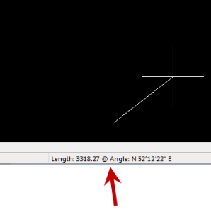
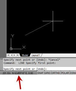
However, if you are currently in a command that requires two points be picked to specify an angle and distance (commands such as Line or Move, etc), you have a 3rd coordinate display available to you: polar coordinates. Unlike rectangular coordinates that display X, Y and Z position, polar coordinates report a distance and angle from the original point. For instance, when you start the Line command you can toggle the coordinate display so that rectangular coordinates are ON or OFF. But, after picking the first point of the line, you can toggle the coordinate display so that rectangular coordinates are ON, rectangular coordinates are OFF or that polar coordinates are ON.
The image below on the left shows the polar coordinate display in AutoCAD and the IntelliCAD version is shown below on the right:
To toggle the coordinate display in newer versions of AutoCAD (since 2009?) double-click on the coordinate display. In older versions of AutoCAD and in IntelliCAD, the F6 button toggles the display.
Special Offer from Esri for Carlson IntelliCAD Users
Since the focus of my class and of the NC Surveyors Show as a whole is GIS, I thought it made sense to bump the information about the free copy of Esri software to the top…
Those currently using Carlson with IntelliCAD are eligible for a new “GIS Starter Kit” from ESRI. The Kit includes:
- ArcGIS ArcView desktop software
- A copy of the book A to Z GIS: An Illustrated Dictionary of Geographic Information Systems
- A copy of GIS Tutorial: Workbook for ArcView 9, Third Edition
- A 10% discount for the ESRI Survey & Engineering GIS Summit ($325 – standard registration price)
To take advantage of the offer, call 1-800-GIS-XPRT (1-800-447-9778) and request the Carlson-IntelliCAD GIS Starter Kit and please have your Carlson Serial Number available.
You can read more about ESRI’s commitment to survey and engineering services by visiting http://www.ESRI.com/engineering.
Another Happy Carlson Customer
Here is a great story about another customer of mine, John Prevette with Gooden & Associates out of Hope Mills, NC, and his successful transition from Civil 3d to Carlson Civil Suite.
http://info.carlsonsw.com/blog-1/bid/121528/Moving-to-Carlson-from-Civil-3D
And, I know what you’re thinking but the answer is “No.” Carlson did not pay him to say this – I asked just to make sure! In all seriousness, it’s great he was willing to be interviewed and confirm just how great a design tool Carlson is and just how quickly you’re able to get up to speed.
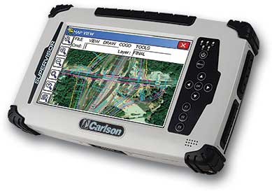
Carlson’s New Supervisor+ GPS Tablet
Many of you saw Carlson’s new Supervisor+ GPS tablet at our workshops last November and December but it’s just now being officially rolled out…
Come by our booth at the NC and SC Surveyor’s Conventions in the next couple weeks and give it a test drive.
Carlson 2012 Updates
You can download the most recent updates to Carlson’s 2012 desktop software HERE
Follow www.CarlsonConnection.com to www.ThatCADGirl.com
This blog is in the process of being transferred to www.ThatCADGirl.com. Please join us there.
End of Year Workshops – Statesville, Asheville, Wilmington and Raleigh NC
We are finally able to announce our end of year workshops for 2011. With the weather problems we encountered last year we decided to hold the events in the western end of North Carolina in November and toward the coast in December.
The cost to attend each event is $99 and lunch is included. See below for early bird registration details for each event. NC Licensed Surveyors and Engineers will receive 8 PDH credits and all attendees will receive a certificate confirming their attendance. We will have door prizes, software giveaways and special software or hardware pricing that is available the day of the show only.
We will be in Statesville on Tuesday, November 15th and Asheville on Thursday November 17th. Early bird registration is $89 through September 30th.
We will be in Wilmington on Tuesday, December 13th and Raleigh on Thursday December 15th. Early bird registration is $89 through October 31st.
You will be able to choose the sessions you wish to attend. This year’s sessions include:
- GIS from A to Z and Responding to GIS-related RFPs
presented by Janet Jackson (GIS Janet) of Intersect - Overview of Carlson Takeoff & Preparing Machine Control Data
presented by Todd Carlson of Carlson Software - Intro to SurvNet & Least Squares
presented by Donnie Stallings, the original developer of the product - CAD Standards Roundtable & Discussion
presented by Jennifer DiBona, That CAD Girl - CAD Tips & Tricks and hints for sharing data with others
presented by Jennifer DiBona, That CAD Girl - Overview of Carlson Software 2012 (Survey, Civil, Hydro, GIS, Point Clouds)
presented by Scott Griffin of Carlson Software - Field to Finish with Carlson Survey & SurvCE and the Surveyor+ GPS System
presented by Butch Herter of Carlson Software and Jeremy Taylor - Preview of future Carlson hardware
presented by Butch Herter of Carlson Software and Jeremy Taylor - Road Design and Site Design with Carlson Civil & Hydrology
presented by Scott Griffin of Carlson Software
Note that all classes are not scheduled at all events and locations. See each workshop announcement for specifics. Seats are limited so register online, call 919.417.8351 or email us to register.
Upcoming Regional Training Classes – Columbus OH, Raleigh NC, Atlanta and Baltimore
After many requests to hold training classes in different areas of the country, I’ve finally managed to schedule a few dates. The classes are 8 hours of hands-on training and seats are limited. Registration deadlines and pre-requisites vary for each class – Click the link below for the class announcement.
Classes include Intro to Survey, Surface Modeling, Least Squares/SurvNet, Quantity Takeoffs and Drawing Prep for Surface Modeling among others.
Call 919.417.8351 or [email protected] to register.
- May 2-3 – Columbus, Ohio
- May 16-18 – Raleigh, North Carolina
- May 23-25 – Atlanta, Georgia
- June 1-2 – Raleigh, North Carolina
- June 14-16 – Baltimore, Maryland


