Understanding Changes to Projections and Zones in Carlson 2024… we have questions!


Carlson Software users starting a new drawing in the 2024 version of the software were met with a significant change in the drawing setup with regard to Projection and Zone. This has led to a lot of questions and confusion about what, if anything, needs to be done when opening older DWG files in Carlson 2024.

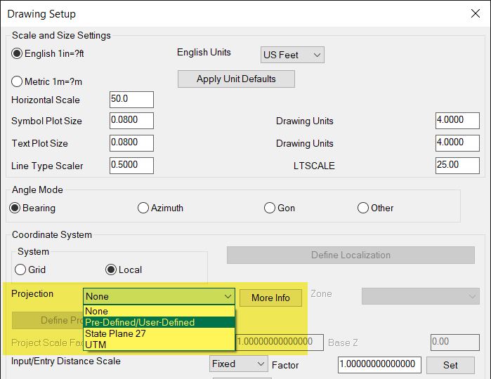
The Startup Drawing Wizard in 2023 is on the left and 2024 is on the right:
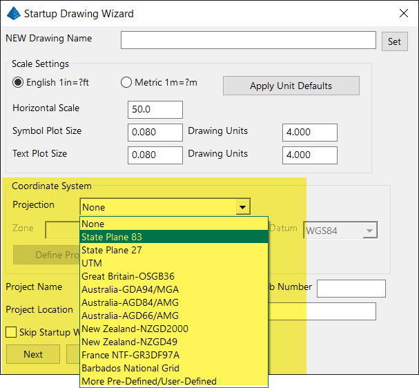
 

We have gotten some questions about this change so we reached out to Doug Aaberg, the Carlson Survey product manager, and asked him to give us a brief explainer about the change and to make himself available for a Q & A session. Luckily, we were able to find a date and time in March so we’re very happy to announce that Doug will be joining us on Thursday, March 21st at 12:00 (ET) for this Webinar session.

Although it was originally planned to be offered only to subscribers of our Webinar Series, this topic is important enough that we know we need to offer it on a wider-scale. There are no pre-requisites, no commitments and no strings – just use the link below to register (to get a reminder) or to join the event in progress.

If you would like to review the recording after you attend or would like a certificate of attendance, please send us an email and let us know you will want those extras.

Click here to register!


Register for Carlson’s “What’s New in 2014” Webinar Series

As we’re all getting ready for the release of Carlson’s 2014 desktop products, Carlson Software has scheduled a series of 5 lunchtime webinars to introduce new features and enhancements. See below for details and registration links:

Carlson Survey and Civil 2014
Wednesday, July 24th – presented by Scott Griffin, Director of Sales

Carlson Construction 2014
Wednesday, July 31st – presented by Todd Carlson, Takeoff Product Manager

Carlson Hydrology 2014 and all new Carlson Trench
Wednesday, August 7th – Mark Long, Developer, & Todd Carlson

Carlson Mining 2014
Wednesday, August 14th – Grant Wenker, Director, Mining Division

All new CADnet
Wednesday, August 21st – Jim Carlson, Regional Sales Director

All new GeoTech
Wednesday, August 28th – Dave Sanford, Regional Sales Director


Sneak Preview – Mass Haul Analysis in Carlson 2014

Todd Carlson helped me out with a demonstration of Carlson Takeoff a couple months ago and the company we were presenting to was looking for some particular features in a mass haul analysis routine. They had looked at several other programs as well as Takeoff and had yet to find a solution to their particular issue.

Fast-forward about a month and Todd followed up to let us know that the new functionality had been incorporated into the software and would be available in Carlson Civil and Carlson Construction/Takeoff 2014. This is a perfect illustration of how responsive Carlson is to their customers (or even prospects, in this case).

I asked Todd to write up a little preview of the new Mass Haul Analysis routine we’ll see in Carlson 2014:

Mass Haul Analysis in a nutshell:
Mass Haul Analysis determines the volume and haul distance for groups of net cut and net fill station ranges along a road. The program calculates the optimized cut to fill movements so that the total volume-distance moved is minimized.

New Feature:
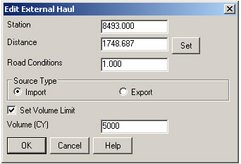
When dealing with multiple external hauls, users can now input the distance (and a “road conditions” factor) a borrow pit or dump pile is from its entry station. The program will then use this information when minimizing earth movement along the road.

For example, as shown in the first graphic below, an image of the area was inserted into the drawing from Google Earth or the Esri Mapping Service. CAD polylines were sketched along the travel paths from multiple pit locations to the project site.

Then, purely based off stationing, borrow pit (A) may be closer to a fill area than borrow pit (B). However, if the distance from borrow pit (B) to its entry station is closer than borrow pit (A)’s, the program may determine to use (B) as the borrow pit over (A) to optimize the earth movement.


Learn more about Carlson Civil and Carlson Takeoff


Does Carlson Still Work With AutoCAD?

File this under “Myths”…

I hope this isn’t widespread, but I received the following email yesterday and think it’s important to respond publicly. The email is posted in its entirety except for the name and contact info of the author.

Hello Jen & Jeremy,

I became acquainted with your site (and I believe Jen was on a “webcast” or video I had watched) when my former employer made the switch from Civil 3D to Carlson Civil several years back. I am an engineer and have been put into the role of upgrading AutoCAD and Carlson or making sure that my current company can continue to do what is necessary, which involves using CAD much less that in my consulting life.

A local Autodesk reseller paid us a visit and indicated that Carlson and Autodesk as companies have not reached an agreement to continue further compatibility. Sounds like a licensing ($$) agreement issue, to me, that may or may not be temporary. This salesperson also indicated that the new version of Carlson would not work with anything beyond AutoCAD 2010 which we are currently running with Carlson 2011. As a note, My former company did not update AutoCAD every year depending upon what features were actually new so I am very OK with not upgrading if not entirely necessary.

I would greatly appreciate any information or insight you could give on the subject. You can reach me via this e-mail or the phone number in the signature.

Kind regards,


I contacted Carlson and requested a direct reply:

Hi Jennifer,

Carlson Software is a current member of the Audodesk Developer Network (ADN) which gives access to the current Autodesk products. We expect to release Carlson’s 2014 products, including those running on top of IntelliCAD, AutoCAD 2014 and AutoCAD OEM, in the Summer of 2013.

Dave Carlson


Also, for the record, I currently run Carlson 2013 on top of IntelliCAD and on top of Civil 3d 2012.


Carlson SurvPC Data Collection Now Works with Esri & MicroStation Files

With a post to their blog last night, Bruce Carlson announced that Carlson SurvPC data collection software (Windows version of SurvCE) can now view and write directly to the Esri .mxd and Bentley Microstation.dgn file formats. This is pretty exciting stuff for both survey field crews and those who wish to design-on-the-fly from the field.

Read more here