Sneak Preview – Mass Haul Analysis in Carlson 2014

Todd Carlson helped me out with a demonstration of Carlson Takeoff a couple months ago and the company we were presenting to was looking for some particular features in a mass haul analysis routine. They had looked at several other programs as well as Takeoff and had yet to find a solution to their particular issue.

Fast-forward about a month and Todd followed up to let us know that the new functionality had been incorporated into the software and would be available in Carlson Civil and Carlson Construction/Takeoff 2014. This is a perfect illustration of how responsive Carlson is to their customers (or even prospects, in this case).

I asked Todd to write up a little preview of the new Mass Haul Analysis routine we’ll see in Carlson 2014:

Mass Haul Analysis in a nutshell:
Mass Haul Analysis determines the volume and haul distance for groups of net cut and net fill station ranges along a road. The program calculates the optimized cut to fill movements so that the total volume-distance moved is minimized.

New Feature:
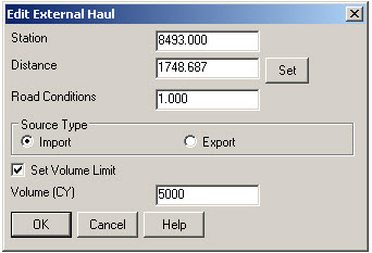
When dealing with multiple external hauls, users can now input the distance (and a “road conditions” factor) a borrow pit or dump pile is from its entry station. The program will then use this information when minimizing earth movement along the road.

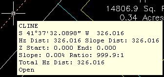
For example, as shown in the first graphic below, an image of the area was inserted into the drawing from Google Earth or the Esri Mapping Service. CAD polylines were sketched along the travel paths from multiple pit locations to the project site.

Then, purely based off stationing, borrow pit (A) may be closer to a fill area than borrow pit (B). However, if the distance from borrow pit (B) to its entry station is closer than borrow pit (A)’s, the program may determine to use (B) as the borrow pit over (A) to optimize the earth movement.


Learn more about Carlson Civil and Carlson Takeoff


The Kansas City Carlson User Group

I’m reflecting on my impressions of the inaugural meeting of the Kansas City Carlson User Group meeting held at the corporate office of Griner & Schmitz on August 20, 2009. About a dozen individuals showed up to form new business relationships with one another and draw on the strengths from their common bond.

The meeting started out with the gracious hospitality of Griner & Schmitz who hosted the event at their corporate headquarters in Kansas City. Complimentary food and beverages were aplenty and the guests quickly found themselves forming or renewing friendships with others in attendance.

After a bit of socializing, the guests were treated to a sneak peek of Carlson SurvCE 2.5 from Carlson Software South Central Regional Sales Director Aaron Newman. Aaron demonstrated many of the new and powerful features of SurvCE and showed the attendees how to leverage the power of the Carlson Field-to-Finish routines. Throughout the presentation, one of the key benefits of a User Group is that questions posed by one individual benefits the others and attendees are generally willing to share their observations and experiences with others. After Aaron’s presentation, I was given the opportunity to demonstrate some of the new features that will be released with Carlson 2010 with particular focus on surveying and the communication of information between the field and the office.

It was amazing at how quickly the two-hour meeting flew by but it is my opinion the Kansas City Carlson User Group is off to a great start. If you’re in the Kansas City area in mid-October for the expected follow-up meeting, consider dropping in for some informational aspects of the products and services offered by Carlson Software. Otherwise, express your interest in forming a Carlson User Group in your region!

Originally posted on Carlson Connection by Ladd Nelson


Carlson 2010 Sneak Peek

The 2010 edition of Carlson Software is a few weeks away from general release and is slated to have approximately 400 new features and enhancements. Suffice it to say, there should be something for just about everyone with this release. While by no means exhaustive, here are just a few of the new features that will be found in Carlson 2010 (a few of which were mentioned in the Coming in Carlson 2010 post):

  1. Support for IntelliCAD 6.6 and the AutoCAD 2010 product line – Carlson 2010 will continue to ship with a complimentary copy of IntelliCAD now based on the 6.6 code stream from the IntelliCAD Technology Consortium. Work continues on the migration to the IntelliCAD 7 release which is expected later this year or early in 2010. Carlson 2010 will also support the AutoCAD 2010 family of products including AutoCAD, AutoCAD Map, et. al. Since Land Desktop was officially retired in summer, 2008, now is a great time for organizations to look at Carlson as an alternative to the Land Desktop upgrade path.

    Side note observation… For those Carlson IntelliCAD users out there, don’t forget to inquire about your complimentary Carlson-IntelliCAD GIS Starter Kit from ESRI!

  2. Settings Explorer for CAD Managers – Carlson 2010 introduces an efficient Settings Explorer that allows CAD Managers and users alike to examine, set and migrate settings from machine to machine within an organization.
  3. Layout Manager and Field Text for CAD Drafters – Geared for deliverable output, the Layout Manager and Field Text routines helps automate the creation of plot-ready maps.
  4. Smart Annotation for CAD Drafters and Surveyors – Carlson 2010 helps simplify the annotation typically applied to subdivisions.
  5. Merging of C&G into Carlson Survey for Surveyors – The long-awaited integration of Carlson’s C&G product line with the more traditional Carlson Survey routines provides land surveyors with arguably the most comprehensive collection of survey routines available today.
  6. Drawing Inspector Multi-select for everyone – The highly useful Carlson Drawing Inspector is becoming even more useful with the ability to now display multiple information categories at once.
    Multi-option Drawing Inspector
    Multi-option Drawing Inspector
  7. Template Grade Table for Engineers – In an effort to augment the highly flexible and powerful Template Transition, Template Point Centerline and Template Point Profile routines found in Carlson Civil, a new Template Grade Table provides robust functionality that can be used to design a variety of roadway scenarios. Additionally, the information found in the Template Grade Table can also be utilized in Carlson SurvCE beginning with the 2.5 version of the product.
  8. Edge of Pavement Profiles for Engineers – The ability to produce the graphical results of edge of pavement profiles is now much simpler with Carlson 2010 by giving engineers the ability to extract profile information from the imperical design values that contribute to the vertical aspect of the roadway design.
  9. HydroCAD Linkage for Hydrologists – As originally announced at the 1st annual Carlson User Conference, the data collaboration between Carlson Hydrology and HydroCAD will help users “save time on repetitious data entry, increasing their accuracy, and giving them access to HydroCAD’s extensive rainfall libraries and stormwater chamber specifications.”
  10. Improved Watershed Delineation for Hydrologists – Watersheds in Carlson 2010 can be delineated by three levels: drainage, land use and soil type.

For Carlson Mining clients that might also happen to come across this post, Carlson 2010 offers new functionality for you, too! Check with your Carlson Mining specialist for additional details.

To summarize, Carlson Software is continuing to offer responsive solutions to client-requested technology needs and is standing ready to assist you! Check out our wide-array of technolgy solutions by visiting us on-line at http://www.carlsonsw.com!

Originally posted on Carlson Connection by Ladd Nelson


Another Twist for World

I’d like to offer a few other arguments for the use of the DVIEW TWIST routines discussed in North Rotation: Using Twist Screen. The four Carlson DVIEW routines cited:

  • Standard – This option allows you to select a rotation angle using the mouse.
  • Line, Polyline or Text – This option allow you to select an object to set as a view baseline.  It is the most useful when trying to match views to objects such as property lines or road centerlines.
  • Surveyor – This option prompts for the manual entry of a bearing or azimuth for the rotation angle.
  • Restore Due North – This option returns the screen to the orientation where North is straight up.

fall right in line with remarks made by ESRI’s Brent Jones at the 2009 Carlson User Conference who said:

“GIS changes the whole domain for surveyors,” Jones added, “And surveyors need to be ready for what’s coming next — high accuracy GIS. The key is geo-referencing,” he said. “We can use our data to communicate to our world with greater precision over greater areas.”

In my opinion, a User Coordinate System (UCS, by its very definition), takes the data one step further away from being geo-referenced. There are those that would probably argue that having data in a World Coordinate System (WCS) and at assumed coordinates of something like 5000,5000,100 is no better than using a UCS to shift this same data to a proper geo-referenced coordinate system. From a holistic stand-point, I’d tend to agree. However, what sets the WCS vs. UCS argument apart is this simple statement:

All drawings must have a WCS yet not all drawings have a UCS.

When one considers the longevity of information represented in drawings created to this point in time and then reflects on how this information might also be used in the future, I feel it is important to model that information (and subsequently allow that information to be easily extracted) in a consistent and reliable fashion. A User Coordinate System is typically only understood and used by its creator which in turn, limits its use and subsequently increases the risk of liability when the User Coordinate System isn’t known or understood by a “downstream” recipient of the drawing (survey stake-out, machine control excavation, etc).

Side note observation… Is it me or are there some parallels between UCS and custom ARX objects used in other products? When I look at how long the DVIEW vs. UCS arguments have been made, I can only surmise the length of time that will be involved to bring the non-proprietary vs. proprietary data argument to a close. I suspect it’s going to be a long, tough road.

In any event, it is my opinion that standardizing on a single WCS should provide more consistent deliverables when the drawings/projects span multiple people, offices and/or disciplines. When properly adopted, using a “twisted view” of geo-referenced data in a World Coordinate System should provide more feature-rich information now and into the future when our data is mapped onto the Earth.

Originally posted on Carlson Connection by Ladd Nelson


Ribbon vs. Menu… Your preference is??

I was reading a recent AP article that was similar to the article entitled Meet Microsoft’s antidote to Vista and saw the following:

You probably don’t know her name, but if you’re using Office 2007, the sleeper hit of the Vista era, you’re already familiar with Larson-Green’s work.

She was the one who banished the familiar system of menus on Word, Excel and other programs in favour of a new “ribbon” that shows different options at different times, depending on what a user is working on.

Hmmm… I’m wondering if she’d be willing to re-think that decision?

 I’m not sure what it is about the ribbon interface but I cannot seem to get used to it. I’ve tried… I mean I’ve really tried to be productive with the Office 2007 ribbon but continually find myself wasting lots of time searching for a particular command whose location I could find instantly in the traditional pull-down menu system used in Windows and Office applications for the past +15 years. The article also said:

“We want to reduce the amount of thinking about the software that they have to do, so that they can concentrate all their thinking on the task they’re trying to get done,” Larson-Green said in an interview.

The task I’m trying to get done?? I’m trying to figure out where all my favorite old commands went for getting my work done. I’m finding that I’m spending more time thinking and searching for commands and having less time for the task(s) I’m trying to get done. Don’t even get me started on the new default file formats for Office files (*.docx, *.xlsx, *.accdb, etc) and having to Save As for those who haven’t adopted Office 2007 and later.

Side note observation… I wonder how soon it will be until Autodesk decides to release a *.dwgx file format? Perhaps the Open Design Alliance should beat them to the punch.

According to the frequently changing Wikipedia write-up on ribbons:

Microsoft has started the process of acquiring a patent on the ribbon user interface concept[2] and licenses the ribbon design to third-party developers royalty-free, as long as the user interface conforms to the Microsoft’s design guidelines and they can get an approval from Microsoft. The ribbon design guidelines are confidential and an evaluation copy is only available when a non-disclosure agreement has been signed.

The Ribbon has been licensed by Autodesk for AutoCAD 2009

My fear is that when I eventually have to migrate out of AutoCAD 2008 (I’m running the ribbon-less AutoCAD 2008 and IntelliCAD and haven’t even looked at AutoCAD 2009/2010), I’ll be too far behind the 8-ball. Maybe I’m too grounded and comfortable with pull-down menus. I still prefer Windows XP over Vista and suspect I’d prefer pull-down menus in my CAD product like many of comments left at AutoCAD 2009 – How do you use the Ribbon? blog. Perhaps it is time to accept the fact that ribbons are likely here to stay. However, if my CAD productivity takes a hit due to the migration to ribbons like my Office productivity took a hit, I suspect I’m “going to have some ‘splainin’ to do.” Personally, I’d love to have a one-to-one chat with Julie Larson-Green (a.k.a. “Microsoft’s antidote to Vista“) to learn why throwing away +15 years of interface familiarity is/was a good idea.

What do you think?

[polldaddy poll=1552888]

Originally posted on Carlson Connection by Ladd Nelson


Brent Jones of ESRI discusses ‘Why GIS Needs Surveyors’

Combining all the GIS and land development technologies that exist today is what Brent Jones suggested surveyors do in his keynote address to the attendees at the 2nd annual Carlson User Conference. Jones, PE, PLS, is the Survey, Cadastre, and Engineering Industry Manager for ESRI, which designs and develops the world’s leading geographic information system (GIS) technology.

To help surveyors accomplish this, Jones announced an upcoming grant program to be offered by ESRI for every Carlson IntelliCAD user. “ESRI is very supportive of Carlson’s development on IntelliCAD and we want to support your users,” said Jones of this specialized grant program being developed exclusively for Carlson IntelliCAD users. “We want to help surveyors leverage their existing resources to help in the GIS market.”  With this offer Carlson IntelliCAD users will be able to access GIS technology and jump-start a GIS practice. Read More

Originally posted on Carlson Connection by Karen Cummings


Dewberry’s Dave Palumbo presents ‘Choosing and Implementing Carlson’

Starting his presentation at the Carlson User Conference by saying “Carlson works for us,” Dave Palumbo, PE, Technology Manager for Infrastructure Services at Dewberry, noted that Dewberry, an ENR top 50 design firm was an early adopter of technology as a differentiator. The evaluation and implementation of three competing solutions took Dewberry more than two years. “Patience was of the essense,“ Palumbo said.

Read the entire post

Originally posted on Carlson Connection by Karen Cummings


BIM vs. “CIM” – Is it a Noun or Verb?

I wanted to share my opinion related to the BIM this, BIM that… What is BIM? article to essentially equate (or draw parallels between):

“Acronym” “Location” “Data” “Mechanism” “Discipline”
BIM Building Information Modeling Architectural
GIS Geographic Information System Civil

If one turns the acronyms around,

  • BIM is another way of saying Owners/Architects who utilize Model Information for Buildings, and,
  • GIS is another way of saying Officials/Civil Engineers who use a System of Information for Geographical projects/studies.

If the message(s) from the Autodesk marketing department

http://usa.autodesk.com/company/building-information-modeling and
http://www.cenews.com/article.asp?id=3137

is/are to believed, Autodesk is expecting the market to swallow the hype that the Civil 3D (C3D) product can function within the confines of a building or as a BIM solution.

I don’t buy this (and in my opinion, neither should the public). By the looks of the responses to a discussion on the C3D newsgroup this past September, 2008:

http://discussion.autodesk.com/forums/message.jspa?messageID=6033685

it looks as if C3D users aren’t necessarily swallowing the attempted message either. As the thread eloquently points out, it largely depends if you take the context of “building” to be a noun or a verb:

  1. Noun http://www.merriam-webster.com/dictionary/building
    – “1 a usually roofed and walled structure built for permanent use (as for a dwelling)”
  2. Verb http://www.merriam-webster.com/dictionary/build[1]
    – “1 to form by ordering and uniting materials by gradual means into a composite whole”

Side note observation… Since GIS is/has been a well established market for other products on the market and is also one that Autodesk does not control, could it be that Autodesk is trying to capitalize on the relative newness of BIM by generalizing the Noun form of BIM into that of a Verb so they can use it to further confuse the market?

Whatever the context, I also feel C3D falls short for BIM in one key aspect; all of the C3D seems to get locked up into the ARX/proxy objects within a given drawing. To my knowledge, C3D doesn’t allow the “Information” aspect of the design to be externalized outside of the drawing. As Civil Engineers and Land Planners look down the road for the next 10 or 15 years (or more), I tend to question how they’ll be able to manage/maintain/extract the data locked away in C3D drawings that are being produced today. As I heard one DOT employee say, their projects typically span years in the design/life cycle. If I were in their shoes, I wouldn’t be looking forward to having to carry around all the LDT/C3D object enablers that will likely come out with each annual release of each C3D product for the next decade or two.

My ¢2.

Ladd Nelson
Sales Director – Midwest Region
Carlson Software

Originally posted on Carlson Connection by Ladd Nelson


Carlson Software Expands Carlson College™

Carlson Software recently expanded their expert level training program, Carlson College™, and started the Carlson College Training Program. This new program will allow individuals and companies to get training direct from Carlson Software or through the members of the Carlson College Training Program. New members of the Training Program include Harken-Reidar Inc. of Front Royal, Va.; Carlson Desktop Solutions (CDS), based in Austin, Texas; That CAD Girl, located near Raleigh, N.C.; and, for C&G products only, Larry Phipps of the Land Surveyor’s Workshop in Jefferson, N.C. Membership in the Carlson College Training Program is available to any person or organization that makes a commitment to providing quality training on Carlson Software products.

For more information on the Carlson College Training Program or training, please contact Carlson Software at 800-989-5028, email [email protected] or visit www.carlsonsw.com/training. Members of the Carlson College Training Program are independent entities from Carlson Software.

Read the entire Press release here.

Originally posted on Carlson Connection by Karen Cummings


How Does Carlson Support Their Users? Ask David Farina

I’m going to post a LONG email stream between one of my clients, David Farina, Bruce Carlson and Dave Carlson. You can see the new feature that David requested and Bruce and Dave’s responses. David received a “development” version of the new features approximately a week after submitting this request.

I asked him for a statement describing his experience with Carlson:

Recently I found that the Time of Concentration input boxes were inadequate under the hydrology portion of Carlson Civil Suite so I emailed a description of the problem to them. I was very impressed to get a phone call the same day. They discussed the problem with me and had a revised program update to me in under a week. I’ve been emailing Autodesk for over a year on problems with Civil 3D and never heard a peep. Needless to say I’m very happy with the customer service I have received from Carlson thus far.

Here is the original question from David Farina on March 4, 2009:

Jennifer,

I was going through a mock project to learn the hydrology part of Carlson and noticed a critical deficiency in Time of Concentration input. The review agencies around here want to see the TR-55 method. First, the TR 55 minimum sheet flow needs to be 100’ instead of 300’. They recently changed it per the TR-55 Web site. Second, I don’t think I’ve ever had a project where you didn’t have to split one of these flow types into 2 or more mannings roughness areas.

For example:  a flow path that starts on dense grass for 50’ then passes over asphalt for 75’ and back to grass for 200’ would need to be calculated as follows:

 Sheet flow 50’ Grass ->  Sheet flow 50’ Asphalt -> Shallow Concentrated flow 25’ Paved -> Shallow Concentrated flow 200’ UnPaved.

But as you can see the Carlson input only allows for one entry per flow type.

 df_01

 df_02


Below is the Intellisolve version:  Notice the A, B C

 df_031


There is a 5.1 minute difference in TC results which results in a 2 CFS difference in the 100yr example below: 

df_04

df_05


If the above example is that different then I am also concerned about how the Time to inlet is calculated in the example below:

 df_06


df_07

Was the SCS method used to get the 7.1 min value? 

Notice the 7.5 value in the TC dialog to the right. 

This was the value if I SELECT FLOW LINE FROM SCREEN and pick the path that the dialog on the left generates.

Can I generate a report of how the time to inlet was calculated? 

Maybe there can be a button next to the Time to inlet to select TR-55

Maybe Mannings coefficients can also be put into the WATERSHED->DEFINE RUNOFF LAYERS to be used for this calc as the flow path passes through each polyline area the same way Carlson already calculates the composite CN.
df_08 

 Will any of this matter if we get HydroCAD and link it to Carlson?  

Just food for thought.


Thank You,

 David Farina

Senior Designer

I forwarded David’s question onto Bruce Carlson, President of Carlson Software, and Dave Carlson, Director of Programming, and received this response from Bruce:

Folks:  Excellent input—this will find its way into the next release for sure.  We’ve spent a lot of time studying Haested and matching numbers there on pipe flows in culverts, for example, covering all conditions—but do need to put to bed Time of Concentration for approved defaults and sub-catchment conditions as they vary within a watershed area.  This Intellisolve example is really helpful.  Also, I took in input at Jennifer’s Statesville, NC presentation Dec. 2007 that mentioned the new 100’ default and also mentioned:

Using Q=CIA, there are new “rules” being published that using larger pipes or it may be larger drainage areas, there is an added multiplier in the form Q=CIA*Q1 where Q1 is a table of values.  I didn’t get the full details, but we need to research this.

And in storm sewer design, if we are compositing the calc of time to inlet using a “short-form” SCS-style method, based on percentage area of various land uses and associated runoff coefficients, we need to have a Report button that documents the results for full vetting and reporting out by users, and we need to incorporate an additional auto-calculated, long-form TR55 time of concentration there as well that uses sheet flow, channel flow and shallow concentrated flow.  One key in all this is to be able to auto-distinguish these flow types from the DTM and land uses and have the forms filled out with default values, which the user can change.  

 Question I’m curious about.  Say you built a gentle 6’wide, 1% slope swale with 6:1 side slopes, hardly noticeable, mowable, between lots in a subdivision.  Would the flow in that be treated as shallow concentrated flow or channel flow?  When would one condition end and another begin, by definition, so we can get real precise on auto-calculating these using layers/land use types and DTM values?

 Good stuff, and it will get done.

Bruce Carlson, PE

Pres., Carlson Software

David added the following:

I think when to use channel flow should be determined by the width of the bottom of the channel and hence how deep the channel gets on an 2yr storm 24 storm.

You could have a channel with 1:1 side slopes but if the bottom was 50’ wide and the flow path started in the channel then

the first 100’ would still be sheet flow in my book. Unless of course a huge amount of water was entering the channel from another basin.

I think the concentrated and channel flow times (being in the fraction of a minute range) are so small and have such a small impact on overall time

compared to sheet flow (fraction of an hour) that you could pick an arbitrary number like 5’ wide bottom and smaller is channel flow and not upset the model.

Sheet flow probably makes up 80 to 90 % of overall TC if it is over grass.

Anyone disagree?

Thank You

Dave Carlson sent this on March 11, 2009


Hi David,

Here’s an update to the Tc by TR-55 routine that allows unlimited number of breakouts. This update is for Carlson 2009 on Acad 2007-09. To install, unzip and copy the arx to the Carlson2009LSP folder. Let me know if you need a different version or have more suggestions.

For the Storm Sewer Network routine, I put it on the to-do list to add a Select button next to the Tc to show the components that make up the Tc like the Select button does for CN. Also we will looks at adding Manning’s n to the Define Runoff Layers for use with Tc calcs.

Thanks for the input.

Dave

Originally posted on Carlson Connection by Jennifer Dibona