They’re Back!! ESRI, I mean!

I got a nice surprise a few weeks ago – a call from Donny Sosa, a Survey Industry Specialist with ESRI. Donny was nice enough to come to North Carolina and present a session at my end-of-year workshops a few years ago.

Even though he gets it, I’m sure Donny groans when he hears the joke that “GIS means Get It Surveyed”… because he & I originally met after he and Brent Jones made their Why GIS Needs Surveyors presentation at a Carlson User Conference in 2009. Since then I’ve understood that he is committed to getting surveyors to provide survey-quality data to public and private GIS-systems so that the quality of the data we all rely on continues to improve.

Donny called because he remembered that a lot of my customers were excited about, and took advantage of, the free GIS Starter Kit that ESRI offered to Carlson’s IntelliCAD users after that presentation and wanted to let me know that the program is back in place.

Here are the details – effective… NOW!

Those currently using Carlson with IntelliCAD are eligible for a FREE “GIS Starter Kit” from ESRI.

The Kit includes 3 books:

  • ArcGIS for Desktop Basic
  • A to Z GIS: An Illustrated Dictionary of Geographic Information Systems
  • Getting to Know ArcGIS for Desktop, Third Edition


To take advantage of the offer, call 1-800-GIS-XPRT FREE (1-800-447-9778 FREE) and request the Carlson-IntelliCAD GIS Starter Kit and please have your Carlson Serial Number available.

You can learn more about ESRI’s commitment to survey and engineering by attending the Esri AEC Summit or by visiting www.esri.com.


They’re Back!! ESRI, I mean!

cad softwareI got a nice surprise a few weeks ago – a call from Donny Sosa, a Survey Industry Specialist with ESRI. Donny was nice enough to come to North Carolina and present a session at my end-of-year workshops a few years ago.

Even though he gets it, I’m sure Donny groans when he hears the joke that “GIS means Get It Surveyed”… because he & I originally met after he and Brent Jones made their Why GIS Needs Surveyors presentation at a Carlson User Conference in 2009. Since then I’ve understood that he is committed to getting surveyors to provide survey-quality data to public and private GIS-systems so that the quality of the data we all rely on continues to improve.

Donny called because he remembered that a lot of my customers were excited about, and took advantage of, the free GIS Starter Kit that ESRI offered to Carlson’s IntelliCAD users after that presentation and wanted to let me know that the program is back in place.

Here are the details – effective… NOW!

Those currently using Carlson with IntelliCAD are eligible for a FREE “GIS Starter Kit” from ESRI.

The Kit includes 3 books:

  • ArcGIS for Desktop Basic
  • A to Z GIS: An Illustrated Dictionary of Geographic Information Systems
  • Getting to Know ArcGIS for Desktop, Third Edition

To take advantage of the offer, call 1-800-GIS-XPRT FREE (1-800-447-9778 FREE) and request the Carlson-IntelliCAD GIS Starter Kit and please have your Carlson Serial Number available.

You can learn more about ESRI’s commitment to survey and engineering by attending the Esri AEC Summit or by visiting www.esri.com.


Robert Green’s “An Open Letter to CAD Software Companies” and a Response from IntelliCAD

If you’re one of the many folks out there who don’t believe that the developers of your CAD software are listening to you… you’re not alone and you should take the time to read Robert Green’s “An Open Letter to CAD Software Companies” in Cadalyst. And, as to the part about feeling like you’re all alone, here is Robert’s follow up describing the overwhelming response to his open letter.

I receive email versions of Robert’s bi-weekly CAD Manager newsletters but had fallen behind and didn’t see the original post until yesterday. If I’d read it when it was first released, my response would have been, “Amen brother!”.

Just yesterday morning I had a conversation with a colleague whose company does Landscape Architecture, Civil Design and Land Planning. They are fully invested in Civil 3d (including much blood, sweat and tears in addition to money, money, money) but they’re as productive as any company I know of with the program. Their main complaint? They feel like Autodesk is pushing them toward Revit and they have no need for the software.

In my own experience, I see the push toward NavisWorks and 3ds Max. I had two seats of Civil 3d until I downgraded one of them to Map last year – only to be “rewarded” with an upgrade to Infrastructure Design Suite (and more money for Subscription) this year. This was supposedly something that owners of a Civil 3d and a Map license were able to opt-in to. I didn’t opt-in. So, it took me several days to get them to un-opt-me-in and revert my licenses back to what I’d purchased. Is it any wonder I’m suspicious of any “bonuses” that come my way because of this?

I don’t know how much Robert intended to point the finger at Autodesk in the original column but, with my experiences described above, the references to BIM (which we’ve long argued was a way for Autodesk to avoid talking about Esri and GIS) and Cloud and other buzzwords, that’s certainly the connection I made in my mind.

Because the Carlson Software I sell now includes IntelliCAD, an alternative to AutoCAD, I passed links to the open letter and the responses to a few folks to get their reaction. Dave Lorenzo, the Development Director for the ITC (IntelliCAD Technology Consortium) took the feedback to heart and, considering the interest in the future of IntelliCAD the past few years, I asked his permission to post his response. I very much appreciate his willingness to let me do so…

I agree that the features mentioned are focused on AutoCAD, but the article is not so much about features as it’s really about the user’s perception if someone is listening. While Autodesk is moving too fast providing features that users don’t want or need, we are not moving fast enough to provide the basic productivity features users are requesting, so it appears we both are not listening to our users. That is the perception we need to fix too.

Our next release has several user requested productivity features and I hope our users will see we are listening. Actually we have always been listening but our rewrite of IntelliCAD 7 took so many resources that there was little time for new features – that situation is finally changing. I believe that there are a lot of unhappy AutoCAD users who want IntelliCAD to be successful, we just need to listen and add those remaining productivity features that are keeping them from making the switch.

End of Year Workshops – New format for 2013

After several years of the same format for our end of year workshops, we’ve changed it up a bit this year.

For the first time, we will have one full day in both Statesville and Raleigh NC dedicated to Surveying and GIS topics and an additional day focusing on Civil and Hydrology topics. Each day will also include a unique presentation of the popular CAD Tips & Tricks session that, hopefully, sends everyone home with something they can use the next day.

In addition, we’re conducting 1/2-day events in Wilmington and Hendersonville (Asheville area) covering a variety of topics.

Each full-day class will give NC licensed surveyors and engineers 8 PDH credits and the 1/2 day events are eligible for 4 PDH credits. All events include lunch, software pricing specials and giveaways.

November 11th, Hendersonville NC – $49 for 4 PDH credits
Download Hendersonville (Asheville) Announcement Here
Register for Hendersonville (Asheville) Workshop Here

November 12th, Survey & GIS Workshop, Statesville NC – $99 for 8 PDH credits
Download Statesville Survey/GIS Announcement Here
Register for Statesville Survey/GIS Workshop Here

November 13th, Civil & Hydrology Workshop, Statesville NC – $99 for 8 PDH credits
Download Statesville Civil/Hydro Announcement Here
Register for Statesville Civil/Hydro Workshop Here

December 9th, Wilmington NC – $49 for 4 PDH credits
Download Wilmington Announcement Here
Register for Wilmington Workshop Here

December 11th, Survey & GIS Workshop, Raleigh NC – $99 for 8 PDH credits
($89 registration thru 10/31/2013)
Download Raleigh Survey/GIS Announcement Here
Register for Raleigh Survey/GIS Workshop Here

December 12th, Civil & Hydrology Workshop, Raleigh NC – $99 for 8 PDH credits
($89 registration thru 10/31/2013)
Download Raleigh Civil/Hydro Announcement Here
Register for Raleigh Civil/Hydro Workshop Here


Sneak Preview – Mass Haul Analysis in Carlson 2014

Todd Carlson helped me out with a demonstration of Carlson Takeoff a couple months ago and the company we were presenting to was looking for some particular features in a mass haul analysis routine. They had looked at several other programs as well as Takeoff and had yet to find a solution to their particular issue.

Fast-forward about a month and Todd followed up to let us know that the new functionality had been incorporated into the software and would be available in Carlson Civil and Carlson Construction/Takeoff 2014. This is a perfect illustration of how responsive Carlson is to their customers (or even prospects, in this case).

I asked Todd to write up a little preview of the new Mass Haul Analysis routine we’ll see in Carlson 2014:

Mass Haul Analysis in a nutshell:
Mass Haul Analysis determines the volume and haul distance for groups of net cut and net fill station ranges along a road. The program calculates the optimized cut to fill movements so that the total volume-distance moved is minimized.

New Feature:
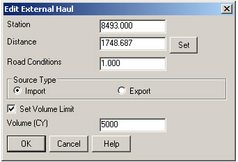
When dealing with multiple external hauls, users can now input the distance (and a “road conditions” factor) a borrow pit or dump pile is from its entry station. The program will then use this information when minimizing earth movement along the road.

For example, as shown in the first graphic below, an image of the area was inserted into the drawing from Google Earth or the Esri Mapping Service. CAD polylines were sketched along the travel paths from multiple pit locations to the project site.

Then, purely based off stationing, borrow pit (A) may be closer to a fill area than borrow pit (B). However, if the distance from borrow pit (B) to its entry station is closer than borrow pit (A)’s, the program may determine to use (B) as the borrow pit over (A) to optimize the earth movement.


Learn more about Carlson Civil and Carlson Takeoff


Freebies from Esri for Users of Carlson with IntelliCAD

I’m re-posting this once more because of the continued interest.

For several years Esri has been offering a FREE “GIS Starter Kit” for anyone who uses Carlson with IntelliCAD. This program will not go on forever but, to my knowledge, is still active. [This offer ended on 12/31/2013]

There are a couple of limitations that I’m aware of: existing Esri customers are not eligible and you can only take advantage of the offer one time… Not once for every seat of Carlson with IntelliCAD that you purchase or own.

The GIS Starter Kit includes:

  • ArcGIS ArcView desktop software
  • A copy of the book A to Z GIS: An Illustrated Dictionary of Geographic Information Systems
  • A copy of GIS Tutorial: Workbook for ArcView 9, Third Edition


If you are a current user of Carlson with IntelliCAD and meet the requirements above, you can call 1-800-GIS-XPRT (1-800-447-9778) and request the Carlson-IntelliCAD GIS Starter Kit – You will want to have your Carlson serial number handy.


Esri GIS Starter Kit for Carlson’s IntelliCAD Users – Repost

[This offer ended on 12/31/2013]

Since there’s a renewed interest in IntelliCAD with the improvements to 7.0, I’ll re-post this…

Those currently using Carlson with IntelliCAD are eligible for a FREE “GIS Starter Kit” from ESRI. The Kit includes:

  • ArcGIS ArcView desktop software
  • A copy of the book A to Z GIS: An Illustrated Dictionary of Geographic Information Systems
  • A copy of GIS Tutorial: Workbook for ArcView 9, Third Edition
  • A 10% discount for the ESRI Survey & Engineering GIS Summit ($325 – standard registration price)

To take advantage of the offer, call 1-800-GIS-XPRT (1-800-447-9778) and request the Carlson-IntelliCAD GIS Starter Kit and please have your Carlson Serial Number available.

You can read more about ESRI’s commitment to survey and engineering services by visiting http://www.ESRI.com/engineering.


That CAD Girl – April 2012 Newsletter

In case you missed it, here is our April 2012 Newsletter


Carlson SurvPC Data Collection Now Works with Esri & MicroStation Files

With a post to their blog last night, Bruce Carlson announced that Carlson SurvPC data collection software (Windows version of SurvCE) can now view and write directly to the Esri .mxd and Bentley Microstation.dgn file formats. This is pretty exciting stuff for both survey field crews and those who wish to design-on-the-fly from the field.

Read more here


Special Offer from Esri for Carlson IntelliCAD Users

Since the focus of my class and of the NC Surveyors Show as a whole is GIS, I thought it made sense to bump the information about the free copy of Esri software to the top…

Those currently using Carlson with IntelliCAD are eligible for a new “GIS Starter Kit” from ESRI. The Kit includes:

  • ArcGIS ArcView desktop software
  • A copy of the book A to Z GIS: An Illustrated Dictionary of Geographic Information Systems
  • A copy of GIS Tutorial: Workbook for ArcView 9, Third Edition
  • A 10% discount for the ESRI Survey & Engineering GIS Summit ($325 – standard registration price)

To take advantage of the offer, call 1-800-GIS-XPRT (1-800-447-9778) and request the Carlson-IntelliCAD GIS Starter Kit and please have your Carlson Serial Number available.

You can read more about ESRI’s commitment to survey and engineering services by visiting http://www.ESRI.com/engineering.