I’ve recently started using a very cool feature in Carlson Software. The bad thing… it was in the 2009 version and I didn’t even realize it!
I had no idea exporting our DWG files from IntelliCAD or AutoCAD out to Google Earth was so easy.
- Download and install Google Earth. You can download it here: http://earth.google.com/
- Open any one of your project DWG files that has been positioned at its correct state plane coordinate system.
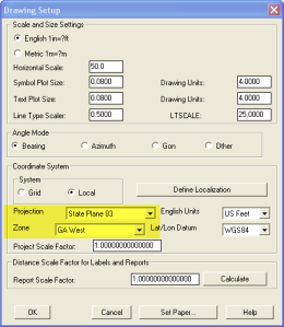
- In Carlson, go to Settings –> Drawing Setup and then select the correct Projection and correct Zone for the project site. If you’re not sure of the Projection, try using “State Plane 83”. This will work for most systems.

- Next, go to File –> Polyline File –> Write Polyline File. When prompted for “Polyline File Format”, type “G” for Google. You will be prompted to specify a new filename and save location for a “Google Earth File to Write (.kml)”.
- You will then be prompted to select the entities that are to be exported out to the .kml file and viewed in Google Earth. After selecting the entities, press Enter. For this exercise, we only want to see the drawing entities in 2D, so press “N” for “No” when prompted to “Use elevation from drawing in Google Earth [Yes/<No>]?”
- Finally, you are then prompted “Would you like to display the file in Google Earth now [<Yes>/No]?”. Press “Y” for “Yes”. Google Earth should automatically launch and zoom into the project location.
In the example shown below and pointed out with arrows, notice how closely the new roads and designed turn lanes match up to the existing roadway. Also, you can see the designed graded slopes perfectly avoiding the tank that is to be preserved during construction.
Not too shabby…
This feature is available in all of the Carlson Desktop products: Carlson Civil, Survey, Hydrology, Construction and TakeOff.
Look for a future post on bringing Google Earth surface data into Carlson Software. Hint: It’s easy too!

