Register for Carlson’s “What’s New in 2014” Webinar Series

As we’re all getting ready for the release of Carlson’s 2014 desktop products, Carlson Software has scheduled a series of 5 lunchtime webinars to introduce new features and enhancements. See below for details and registration links:

Carlson Survey and Civil 2014
Wednesday, July 24th – presented by Scott Griffin, Director of Sales

Carlson Construction 2014
Wednesday, July 31st – presented by Todd Carlson, Takeoff Product Manager

Carlson Hydrology 2014 and all new Carlson Trench
Wednesday, August 7th – Mark Long, Developer, & Todd Carlson

Carlson Mining 2014
Wednesday, August 14th – Grant Wenker, Director, Mining Division

All new CADnet
Wednesday, August 21st – Jim Carlson, Regional Sales Director

All new GeoTech
Wednesday, August 28th – Dave Sanford, Regional Sales Director


Sneak Preview – Mass Haul Analysis in Carlson 2014

Todd Carlson helped me out with a demonstration of Carlson Takeoff a couple months ago and the company we were presenting to was looking for some particular features in a mass haul analysis routine. They had looked at several other programs as well as Takeoff and had yet to find a solution to their particular issue.

Fast-forward about a month and Todd followed up to let us know that the new functionality had been incorporated into the software and would be available in Carlson Civil and Carlson Construction/Takeoff 2014. This is a perfect illustration of how responsive Carlson is to their customers (or even prospects, in this case).

I asked Todd to write up a little preview of the new Mass Haul Analysis routine we’ll see in Carlson 2014:

Mass Haul Analysis in a nutshell:
Mass Haul Analysis determines the volume and haul distance for groups of net cut and net fill station ranges along a road. The program calculates the optimized cut to fill movements so that the total volume-distance moved is minimized.

New Feature:
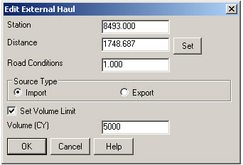
When dealing with multiple external hauls, users can now input the distance (and a “road conditions” factor) a borrow pit or dump pile is from its entry station. The program will then use this information when minimizing earth movement along the road.

For example, as shown in the first graphic below, an image of the area was inserted into the drawing from Google Earth or the Esri Mapping Service. CAD polylines were sketched along the travel paths from multiple pit locations to the project site.

Then, purely based off stationing, borrow pit (A) may be closer to a fill area than borrow pit (B). However, if the distance from borrow pit (B) to its entry station is closer than borrow pit (A)’s, the program may determine to use (B) as the borrow pit over (A) to optimize the earth movement.


Learn more about Carlson Civil and Carlson Takeoff


Carlson SurvCE 3.0 and SurvPC 3.0 Released

From Carlson’s website:

Featuring hundreds of additions and improvements, Carlson SurvCE 3.0 supports the widest range of popular and new release RTK GPS and conventional/robotic total stations of any other data collection software on the market.

SurvCE 3.0 has been released and is now ready for download. Constantly being upgraded, SurvCE features an optional icon-based interface and new Cloud-based messaging, file transfer, NGS monument recall, simplified stakeout methods and powerful GPS measurement averaging and blunder detection in the field (with accuracies in-between RTK and post-processing).

The Carlson SurvCE 3.0 upgrade is offered for just $150 for Carlson customers already using SurvCE 2.0 and above. The price to purchase SurvCE remains the same as it has since 2007.

Literally 100s of enhancements have been built into SurvCE 3.0.


Click here for SurvCE 3.0 Features

Click here for SurvCE 3.0 Screen Shots

Click here for SurvCE 3.0 System Requirements

Click here for SurvCE 3.0 Supported Hardware


Click here to purchase and also, sign up here for our newsletters to be notified of upcoming hardware and software special discounts!


Carlson Geoid12 files for SurvCE

For those who have been waiting, patiently or not, for a Carlson update that will allow you to create a Geoid 2012 file for your Carlson SurvCE collector – here is the update from Carlson.


Carlson 2013 Has Been Released

Carlson released the 2013 version of their desktop products today. This includes: Civil Suite, Civil, Survey, Hydrology, GIS, Takeoff, Construction, Point Cloud, Geology, Surface/Underground Mining and Natural Regrade.

The 2013 embedded-AutoCAD versions of Takeoff and Survey have not yet been released.

Unlike previous versions of Carlson that support running on top of IntelliCAD or AutoCAD products 2000-2012, Carlson 2013 can only be run on IntelliCAD or AutoCAD products 2004-2013. This includes AutoCAD, Map, Land Desktop and Civil 3d. Also, anyone using the FREE IntelliCAD that comes with Carlson is eligible for a FREE GIS Starter Kit from Esri which includes ArcMap.

You can download Carlson 2013 here.

If you are using 2012 and are current on your annual maintenance contract, you can click here to look up your new 2013 serial number online. You will need to enter your contact information and your 2012 serial number in order to generate the 2013 serial number. You can find your serial number by opening Carlson Software and going to Help > About Carlson Software > Change Registration.

If you have trouble finding your serial number or would like to know the cost to upgrade to 2013, please email me with your request.

Click here for the full list of improvements to Carlson 2013

Click here for improvements to the General commands in 2013

Click here for the additional data file & conversion support in Carlson 2013

Click here for improvements to Survey commands in 2013

Click here for improvements to Civil commands in 2013

Click here for improvements to Hydrology commands in 2013

Click here for improvements to GIS commands in 2013

Click here for improvements to Takeoff commands in 2013

Click here for improvements to Point Cloud commands in 2013

Click here for improvements to Geology commands in 2013

Click here for improvements to Surface/Underground Mining commands in 2013

Click here for improvements to Natural Regrade commands in 2013


New Carlson Build with IntelliCAD 7.x Updates

On May 24, 2012 Carlson posted a new build on their downloads page. This brings the Carlson Civil Suite products, (Survey, Civil, Hydrology, GIS), Takeoff, Construction, Point Clouds and Mining, etc. up to build 120524 and IntelliCAD 7.x up to 7.1.1644.53233.P. There are a lot of big updates to stability and productivity in this release.

And, just as a reminder to anyone wanting access to more regular updates to IntelliCAD 7.x, send me an email and I’ll help you get access to a separate, private blog being maintained for users interested in trying out test versions of the software before they’re provided to the general public.


New Carlson Build – 120219

Carlson released a new build of their desktop software earlier this week. This includes updates to the IntelliCAD/for AutoCAD versions of Survey, Civil, Hydrology, GIS, Basic Mining, Geology, Underground Mining, Surface Mining, Natural Regrade, Field, Takeoff, Construction and Point Clouds.

To confirm your current build number, go to Help > About Carlson. You’ll see the build number on the top line of the text box.

You can download the latest full version or updates to your current installation here.

If you would like to try out any of the Carlson Software products for 30-days, email me here.

For those anxious to try out the very latest and greatest updates in the testing versions of IntelliCAD 7.1, you can also send me an email to gain access to a new blog, “The Little CAD Engine That Could”, administered by Leonid Entov of Carlson Software.

Participation in the testing and access to the blog is by invitation only, so email me and I’ll pass along your request.


Carlson 2012 Updates

You can download the most recent updates to Carlson’s 2012 desktop software HERE


Carlson 2012 Has Been Released

Carlson Software released the 2012 version of their desktop software products today. A complete list of Improvements in 2012 can be found here. The newest version can be downloaded here. Current customers who are eligible for automatic upgrade to 2012 can automatically generate your new 2012 serial number by following this link and providing your current 2011 serial number.

Products released today include Civil Suite, Survey, Civil, Hydrology, GIS, Point Cloud, Construction and Takeoff among others. Only the products for installation with IntelliCAD or on top of your AutoCAD have been released at this time. The versions of Survey and Takeoff with embedded AutoCAD will be released in the next several weeks.

After so many years keeping their prices the same, you will notice that Carlson has slightly increased the prices of Civil Suite, Survey, Civil, Hydrology & GIS. In my opinion and even with the price increase, Carlson continues to offer the most bang for the buck when compared to other civil/survey/construction packages on the market today.

To find out about purchasing or upgrading, you can visit our new Online Store or our Carlson Pricing & Upgrades page. Or, feel free to call 919.417.8351 or Email Us with questions.


What is Carlson up to?

This is a good article about Bruce Carlson and where Carlson Software is planning to go in the future…

Independence All the Way

Originally posted on Carlson Connection by Jennifer Dibona