What is LandXML?

This article originally appeared in the April 2011  issue of Professional Surveyor magazine.

The ability to import and export LandXML data has been around for quite a while, but I still get a lot of curious looks when I mention it in my training classes. So, what is it, and why should you be using it?

What Is LandXML?

LandXML refers to a file format (.xml) containing data that has been generated from a civil engineering or land surveying software program.

If you’re hearing about it for the first time and want to learn more about the uses and acceptance of the LandXML initiative, visit www.landxml.org. According to their page LandXML.org in a Nutshell, “… LandXML.org is committed to providing a non-proprietary data standard (LandXML), driven by an industry consortium of partners.”

Simply put, the easiest way to convert, transfer, and archive data between Civil 3D, Carlson Software, Land Desktop, Eagle Point, TerraModel, and many other programs is to use the Import from LandXML and Export to LandXML functions available in these programs. Additionally, many machine control systems allow you to import LandXML files. I am most familiar with the Carlson and Autodesk families of civil/survey programs, so most examples in this article refer to them.

This may not be current by the time you read this article, but the list of members and participating organizations is at www.landxml.org/org.htm.

Why You Should Use It To Transfer Data

The two key words in the mission statement above are “non-proprietary.” Just as we have multiple proprietary drawing file formats such as .dwg (from Autodesk’s AutoCAD-based programs) and .dgn (from Bentley’s Microstation), the files that store survey and civil data such as points, surfaces, centerlines, and profiles are unique and proprietary to their manufacturer.

For instance, Civil 3D is the survey/civil product for Autodesk. Points and surfaces created in that program are stored inside the .dwg file. If you have Civil 3D and need to share a surface with a consultant or other team member who owns the same version of Civil 3D, you can just send them the .dwg file and they will have full access to the point and surface data. However, if you have Civil 3D and your consultant uses an earlier version of Civil 3D, Land Desktop, or Carlson Software or needs the surface data for machine control, it will not be as simple as just sharing the .dwg file.

Similarly, surfaces created in Carlson Software are saved in a .tin file and points are stored in a .crd (coordinate) file. Anyone using Carlson Software or SurvCE data collectors can load these files in their native format. But, Civil 3D or other survey/civil programs can’t access them directly.

As you probably already know, when you have to pass this data onto someone using a different program, it’s a nightmare! This is where LandXML is a lifesaver.

I like to explain that you use Land-XML files in the same way you used to rely on .dxf files. It’s mostly outdated now, but a .dxf file is a generic drawing file (DXF = Drawing Interchange File) that can be exported from and imported into various CAD programs. Back in the day, AutoCAD wasn’t able to read or import Microstation’s .dgn files and Microstation wasn’t able to read or import AutoCAD .dwg files, but both could export and read .dxf files. To get a Microstation file into AutoCAD, we had to export a .dxf file from Microstation and import it into AutoCAD and vice versa.
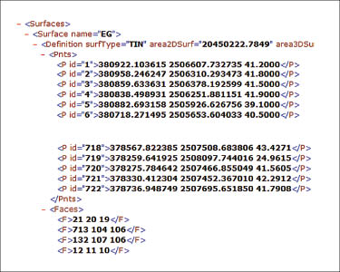
When you export your civil/survey data to an .xml file, it can be opened and read like a text file. Specifically, an .xml file is an .html file that is best viewed through a web browser such as Internet Explorer or Firefox. For instance, when a surface model (TIN) is exported to an .xml file, the X, Y, Z values of each point on the TIN are assigned a number, and then each “face” (triangle) of the TIN is defined by specifying the three corners (Figure 1).

Another benefit of using LandXML to transfer project data is that you can be selective in choosing what project data to include in your .xml file. For instance, in the course of a design project, you may create an existing ground surface, a proposed ground surface for phase one of your project, and a proposed ground surface for phase two. You may have a consultant who needs only your proposed ground surfaces. When you export the .xml file, you have the ability to select only those surfaces that you’d like to add to the file; it’s not necessary to export them all.

For Project Archiving

We’ve all become accustomed to saving archive copies of our drawing files for various purposes, but saving the corresponding project data such as points, point groups, surfaces, centerlines, and profiles is often overlooked. Retrieving the drawing file (.dwg or .dgn) may allow you to recover the linework that represents contours or a profile, but the underlying “surface” is lost unless the project data was also archived.

When archiving your projects at completion or even at submittal time, it is not enough to simply save a copy of the drawing file(s) for the project; you must also save a copy of the project data. At a minimum, the archive should contain the project data in its native format. In the case of Civil 3D, saving your project data in its native format means saving a copy of all .dwg files that store points, surfaces, or other data relating to your project. Saving this project data in its native format is sometimes the easiest method, but it can also create a problem with file storage because the files can become enormous.

This won’t be a surprise, but even if you archive your project data in its native format, I recommend that you consider additional archiving in .xml format. This is the case whether you need to save a progress, submittal, or final archive of your data. No one knows what kind of data files we’ll be using 10 or 20 years down the road, so saving your data in such a generic, text-based format such as .xml files allows for easier retrieval regardless of when you need it.

Note that, like archiving in native format, archiving to an .xml file can also produce very large files. I still believe using the .xml format is advantageous because of the generic nature of the data and having the ability to pick and choose the data you need to archive.

I hope you’ve gotten some clarification on this fantastic tool we’ve all had for years but many of us have not taken advantage of. If you have questions, please don’t hesitate to follow up.

This article originally appeared in the April 2011 issue of Professional Surveyor magazine.


What is Carlson up to?

This is a good article about Bruce Carlson and where Carlson Software is planning to go in the future…

Independence All the Way

Originally posted on Carlson Connection by Jennifer Dibona


Carlson Software Manuals

Looking for Carlson Software manuals? Prior to the 2010 release, Carlson included printed manuals with your purchase and, in addition, the manuals have always been available to print for yourself from the Help files.

With the 2010 release, Carlson “opened” a storefront on the self-publishing site called Lulu.com. You can order 2009 and 2010 Carlson Software manuals here http://stores.lulu.com/carlsonsw.

Originally posted on Carlson Connection by Jennifer Dibona


Export IntelliCAD or AutoCAD DWG files to Google Earth

I’ve recently started using a very cool feature in Carlson Software. The bad thing… it was in the 2009 version and I didn’t even realize it!

I had no idea exporting our DWG files from IntelliCAD or AutoCAD out to Google Earth was so easy.

  1. Download and install Google Earth. You can download it here: http://earth.google.com/
  2. Open any one of your project DWG files that has been positioned at its correct state plane coordinate system.
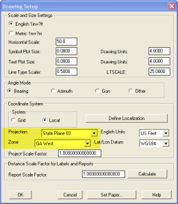
  3. In Carlson, go to Settings –> Drawing Setup and then select the correct Projection and correct Zone for the project site. If you’re not sure of the Projection, try using “State Plane 83”. This will work for most systems.
  4. Next, go to File –> Polyline File –> Write Polyline File. When prompted for “Polyline File Format”, type “G” for Google. You will be prompted to specify a new filename and save location for a “Google Earth File to Write (.kml)”.
  5. You will then be prompted to select the entities that are to be exported out to the .kml file and viewed in Google Earth. After selecting the entities, press Enter. For this exercise, we only want to see the drawing entities in 2D, so press “N” for “No” when prompted to “Use elevation from drawing in Google Earth [Yes/<No>]?”
  6. Finally, you are then prompted “Would you like to display the file in Google Earth now [<Yes>/No]?”. Press “Y” for “Yes”. Google Earth should automatically launch and zoom into the project location.

In the example shown below and pointed out with arrows, notice how closely the new roads and designed turn lanes match up to the existing roadway. Also, you can see the designed graded slopes perfectly avoiding the tank that is to be preserved during construction.
Not too shabby…

This feature is available in all of the Carlson Desktop products: Carlson Civil, Survey, Hydrology, Construction and TakeOff.

Look for a future post on bringing Google Earth surface data into Carlson Software. Hint: It’s easy too!

Originally posted on Carlson Connection by Jennifer Dibona


PDF Conversion in Carlson 2010

With more construction bid sets being issued in Portable Document Format (PDF), more companies find themselves in the position of needing to generate estimating and construction data from these files. Carlson Software now provides tools to import PDF files into a drawing as either an image or as CAD linework. These tools are available exclusively through Carlson Takeoff 2010 and the new Carlson Construction 2010.

To import a PDF file into your CAD drawing, go to the Tools pull-down menu, then choose Import/Export, then choose Import PDF. You will be prompted to select whether you want the file imported as a background image or as linework. If you choose the linework option, it will automatically convert the elements of the PDF image into separate polylines. Please note, since this is an automatic conversion, it may take a while, so be patient as it processes.

Once the polylines have been brought into the drawing, you can use the standard clean-up tools to assign elevation information to these polylines. These tools can elevate polylines representing contours (single elevations) as well as those representing breaklines (varying elevations). This can be done with most of the Carlson desktop software modules including Takeoff, Construction, Survey, and Civil.

Once the polylines have been updated with the elevation information, they can be used to create surface models for design, estimating, staking, or machine control. This procedure can literally save hours of time that used to be spent manually recreating the information released as paper drawings or PDF files. Digitizing may have become a thing of the past!

Originally posted on Carlson Connection by Felicia Provencal


Carlson Webinars – BIM, GIS and CAD Standards

Carlson Software recently asked Felicia and me to present webinars on topics we have particular interest in or specialize in. 

Felicia’s webinar on BIM, GIS and Carlson Software can be viewed here: BIM, GIS and Carlson Software Webinar

My webinar on CAD Standards can be viewed here: CAD Standards for Carlson Software with AutoCAD or IntelliCAD

Originally posted on Carlson Connection by Jennifer Dibona


What’s In Your Surface?

With the adoption of machine control for construction, the ability of various GIS systems to accept 3D data, and now with the expansion of the term BIM to cover elements outside of a building proper, surface modeling has become a critical aspect of any project.  Since so many elements down the line rely on the surface model, it is critical that the model be as accurate as possible and free of errors.  This article will be the first in a series that will take a look at various tools and options within the Carlson product line to ensure the accuracy of your surface models, sometimes known as triangulated irregular networks (TIN) or digital terrain models (DTM).

In this first article, we will take a look at quality assurance/quality control (QA/QC) and how it applies to surface modeling.  This is an essential step of the model building process, and one that is often overlooked by software manufacturers.  For most people, the QA/QC process generally involves examining the contours and looking for issues, or spot-checking points on the surface.  All current surface modeling software allows for the generation of contours and spot-checking, but these rely on the user to manually review the entire surface after it has been built.

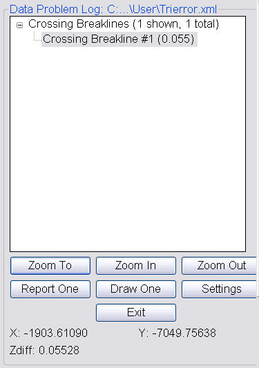
Carlson Software is one of the few products that include an error checker as part of the surface building process.  Most other programs either return a generic error message, or simply fail to complete. If you use the Triangulate & Contour routine, an error log is displayed showing any major issues after the surface data is processed.

Surface Error Log

The issues listed include the following:

  • Crossing breaklines
  • T-Intersections between breaklines
  • Vertical faces

If there are no issues with a surface model, the error log is not displayed.  You can use the various options to change the sensitivity of the error checker, and to highlight any issues found.  Simply select a single error on the log, then click Zoom In.  You can then either correct the errors using any of the surface editing tools, edit the original data (such as the breaklines) and rebuild, or choose to ignore the errors if they are minor.

Although no errors may be found as part of the surface creation, there may still be errors in the surface model resulting from bad data.  Once the surface has been built and any build errors have been corrected, you should do a manual review of the spot elevations and contours.  The easiest way to check and verify spot elevations in Carlson is by using the Surface Inspector, which is available from the Surface pull-down menu of various modules.  After you select the Surface Inspector command, you can change options as to which surface(s) you want to examine, as well as labeling settings.  Once this has been done, move your cursor over the surface previously specified and a floating dialog box will show you information about that surface.  Click anywhere on the surface to label a specific point.

Surface Inspector

Press Enter to exist the Surface Inspector.

By taking just a little time to verify that your surface model is accurate and free of errors, you can save time, money, and effort in the later stages of your projects.  The Surface Error Log is an invaluable tool for locating any errors and flagging them for editing at a later time.  The next article in this series will look at checking a surface model using contours.

Originally posted on Carlson Connection by Felicia Provencal


Online Training – Friend or Foe?

With the economy what it is and everyone trying to get as much bang for their buck as possible, I’m finding that online training for your CAD software programs is an increasingly popular and cost effective option.

Although this post describes my personal approach and may be different considering your trainer, hopefully it will answer some of your questions about online training and will encourage you to give it a try.

How does it work?
There are several online services that trainers may use for online training. WebEx, GoToMeeting and GoToWebinar are all very commonly used and popular. My preference is GoToMeeting and GoToWebinar as they have a very low footprint on your computer and are simple to use. When first entering an online meeting, a small installation of the program occurs allowing you to view and interact with the presenter’s computer.

GoToMeeting is smaller scale and better for personalized training. GoToWebinar can handle up to 1,000 “attendees” and is typically used for presentation or demonstration to a large group.

Some of the online meeting services are free, but most require a monthly fee. The fee is paid by the organizer who then has the ability to schedule meetings/webinars in advance or “Meet Now” for meetings on the fly. Your organizer will either email you a link to the meeting site or can tell you the link on the phone. Each meeting has a unique “Meeting ID” that you’ll enter at the main page.

GoToMeeting is typically used for standard training where more than one person may need to show their screen and/or be given control of the mouse and keyboard. This interaction can take place in a variety of ways. When in a meeting, anyone can be given (and must accept) the “Presenter” role which allows others to view their computer. And, even though the Presenter always has priority, control of the mouse movement and keyboard entry may be granted to others in the meeting. This allows someone else to work on my computer remotely.

The audio portion of the training usually takes place by calling in on a conference call line supplied by GoToMeeting. VOIP (Voice Over Internet Protocol) is also available allowing you to use your computer’s speakers and microphone but it is not recommended because of quality.

GoToWebinar is used for larger scale demonstration and presentations and can accommodate up to 1,000 Attendees. Online Webinars are generally structured to have one or more Presenters making the presentation.

Like GoToMeeting, the audio portion of GoToWebinar usually takes place by calling in on a conference call line supplied by GoToWebinar. However, in a Webinar setting, the Attendees are muted automatically by the Presenter so that everyone isn’t blessed with the sound of crinkling potato chip bags and elevator music when someone puts the phone on hold. The Presenter has the ability to un-mute one or more Attendees as needed. The audio of all Attendees is managed by the Presenter by having each Attendee enter a unique “Audio PIN” upon arrival.

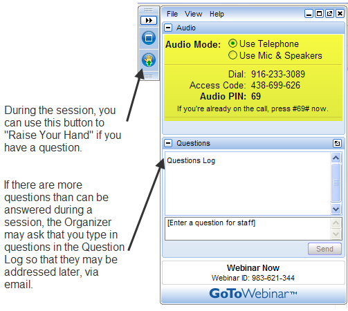
GoToWebinar has 2 ways to ask and respond to questions from Attendees. The Control Panel has a “Raise Your Hand” button that notifies the Presenter there is a question. Depending on time constraints, the Presenter may decide to un-mute and answer the question during the online session.  If there are more questions than can be answered during a session, the Organizer may ask that you type in questions in the “Questions Log” so that they may be addressed at a later time.

GoToWebinar_ControlPanel2

Pros and Cons 
I’ve put together what I consider to be the Pros and Cons of online training for CAD Software programs. Please pitch in and offer your comments.

Pros

  • Can eliminate travel time and expenses
  • Very cost effective option for customized one-on-one training
  • Allows for personalized, absolutely customized training because it’s normally one on one.
  • Can’t find a local trainer? No problem. Felicia Provencal can train you from Hawai’i – although you may want to go to her!
  • Can be set up within minutes if there is a pressing technical support issue or project that suddenly comes up.
  • Can be scheduled in shorter blocks of time – one of the best ways to make sure you retain what you are taught. I like to schedule 2 hours maximum per session.
  • Shorter blocks of time allow for easy customization of training topics from one session to the next. If more time is needed on certain features, it’s easy to squeeze in another 2 hour session.
  • It IS interactive!
  • All sessions can be recorded and played back at your convenience for a refresher.

Cons

  • Some people are more comfortable sitting beside and working directly with the trainer
  • It’s less interactive than hands-on, in person training.
  • For hands on training and depending on the material being covered, it may not work as well if you have several folks needing training at one time.
  • Requires a high-speed connection and a telephone headset allowing two hands on keyboard. A speakerphone can be used as long as feedback doesn’t become an issue.

Real World Example
I recently worked with a client from out of state. He is a grading contractor who thought he needed Carlson TakeOff training but, after some discussion, realized training in basic CAD (IntelliCAD) needed to come first and then TakeOff training.

The initial proposal was for me to travel there and spend 3-4 days training this client plus a second person (a competitor, in this case) who needed the same training. Both of them decided to give online training a try.

We scheduled online training for every morning one week. I worked with one from 7:30 – 9:30 am and then with the other from 10:30 – 12:30 pm. After the 3rd day, we had covered so much material that one asked to skip the next day so he could work with it himself and apply what he’d learned so far.

We ended up skipping two days. By the time we met again, he’d worked with it enough and become so much more proficient with the basic CAD operation that we were able to fast-forward through the next couple sessions and started working on his current project. Another subsequent session was cancelled because the rain finally stopped!

And then a few days later, he needed to get his project finished and out to bid. So, after our first session one morning, we set up another session at 4:00 that afternoon and worked until almost 7:00 that evening.

Both customers ended up very happy with the amount of material we covered and where they were with the software when we wrapped up our regular training. They still have the video recordings of the training for their reference to go back to when needed. In the end, the cost was almost the exact same as it would have been had I fulfilled the original proposal but they both learned and retained much more because the training was customized and personalized to their specific jobs.

Originally posted on Carlson Connection by Jennifer Dibona


The Power of LandXML

 The ability to import and export to LandXML has been around for quite awhile, but I still get a lot of curious looks when I mention it in my training classes. So, what is it? And why should you be using it?

Why Should We Be Using It?

We’ve all become accustomed to saving archive copies of our drawings for various purposes but saving the corresponding project data is often overlooked. Retrieving the drawing file may allow you to recover proposed contours and profile grid, but the underlying “surface” is lost unless the project was also archived.

Importing and exporting using XML files is the most convenient way to convert, transfer and archive data created in Carlson Software, Land Desktop, Civil 3D, Eagle Point, TerraModel and, I’m sure, other programs.

But, What Is LandXML?

LandXML refers to a file format (.xml) containing data created in a civil/survey program. My recommendation is that ALL civil and survey data should be archived – progress, submittal and final archive – using LandXML.

The way I like to explain it is that we use XML files in the same way we used to rely on DXF files. They’re mostly outdated now, but DXF files are a generic file format that, for example, we used to convert MicroStation DGN files to AutoCAD DWG files. At that time, AutoCAD couldn’t read DGN files and Microstation couldn’t read DWG files; but both could read DXF files. So, we had to convert our drawing files to the generic DXF format that could then be read into the other program.

Similarly, Carlson Software, Land Desktop, Civil 3D and the other programs create their own unique files for civil/survey project data such as points, point groups, surfaces, centerlines, profiles, etc. When we have to pass that data onto someone using a different civil/survey program – it’s a nightmare!

That’s where LandXML files prove their value.

Exporting your civil/survey data to an XML file breaks it all down into, basically, a text file. Specifically, it’s an HTML file that can be viewed through a web browser such as Internet Explorer or Firefox. For instance, when a surface model (TIN) is exported to XML, the X, Y, Z values of each point on the TIN is assigned a number, and then each “face” (triangle) of the TIN is defined by specifying the 3 corners. See the examples below:

xmlpost_01 

xmlpost_02

Note that one type of data that is currently not supported in XML files is typical cross-sections or template files.

Another benefit of using LandXML to transfer or archive project data is that any combination or all of your project data can be saved in a single XML file. This is valuable because exporting ALL of the data for a project can create a massive XML file.

Even if you archive your project data in its native format, you should consider additional archiving in XML format. No one knows what kind data files we’ll be using 10 or 20 years down the road so saving your data in such a generic, text-based format such as XML files allows for easier retrieval down the road.

Originally posted on Carlson Connection by Jennifer Dibona


A Closer Look at the Drawing Inspector

There are times when you need to know information about an object in your drawing such as its layer, elevation, or direction and distance.  The Drawing Inspector provides a quick and easy way to gather information about drawing entities on the fly.  Simply turn on the Drawing Inspector using the Inquiry pull-down menu, then hover your mouse over any entity.  Soon the information you require will be displayed in a tooltip next to your mouse location.

This command is available in any of the Civil Suite products (Survey, Civil, Hydrology, and GIS), or Takeoff.  It works in both software installed on the AutoCAD platform or the IntelliCAD platform.  By default, it will display the layer an object resides upon in the tooltip, but you can change the type of information shown using the right-click context menu.

The right-click context menu displays the options for the Drawing Inspector

When you are finished viewing information about your drawing objects, right-click and choose the Turn Off Drawing Inspector option.  You can also toggle the Drawing Inspector off using the Inquiry pull-down menu.
Originally posted on Carlson Connection by Felicia Provencal