They’re Back!! ESRI, I mean!

I got a nice surprise a few weeks ago – a call from Donny Sosa, a Survey Industry Specialist with ESRI. Donny was nice enough to come to North Carolina and present a session at my end-of-year workshops a few years ago.

Even though he gets it, I’m sure Donny groans when he hears the joke that “GIS means Get It Surveyed”… because he & I originally met after he and Brent Jones made their Why GIS Needs Surveyors presentation at a Carlson User Conference in 2009. Since then I’ve understood that he is committed to getting surveyors to provide survey-quality data to public and private GIS-systems so that the quality of the data we all rely on continues to improve.

Donny called because he remembered that a lot of my customers were excited about, and took advantage of, the free GIS Starter Kit that ESRI offered to Carlson’s IntelliCAD users after that presentation and wanted to let me know that the program is back in place.

Here are the details – effective… NOW!

Those currently using Carlson with IntelliCAD are eligible for a FREE “GIS Starter Kit” from ESRI.

The Kit includes 3 books:

  • ArcGIS for Desktop Basic
  • A to Z GIS: An Illustrated Dictionary of Geographic Information Systems
  • Getting to Know ArcGIS for Desktop, Third Edition


To take advantage of the offer, call 1-800-GIS-XPRT FREE (1-800-447-9778 FREE) and request the Carlson-IntelliCAD GIS Starter Kit and please have your Carlson Serial Number available.

You can learn more about ESRI’s commitment to survey and engineering by attending the Esri AEC Summit or by visiting www.esri.com.


They’re Back!! ESRI, I mean!

cad softwareI got a nice surprise a few weeks ago – a call from Donny Sosa, a Survey Industry Specialist with ESRI. Donny was nice enough to come to North Carolina and present a session at my end-of-year workshops a few years ago.

Even though he gets it, I’m sure Donny groans when he hears the joke that “GIS means Get It Surveyed”… because he & I originally met after he and Brent Jones made their Why GIS Needs Surveyors presentation at a Carlson User Conference in 2009. Since then I’ve understood that he is committed to getting surveyors to provide survey-quality data to public and private GIS-systems so that the quality of the data we all rely on continues to improve.

Donny called because he remembered that a lot of my customers were excited about, and took advantage of, the free GIS Starter Kit that ESRI offered to Carlson’s IntelliCAD users after that presentation and wanted to let me know that the program is back in place.

Here are the details – effective… NOW!

Those currently using Carlson with IntelliCAD are eligible for a FREE “GIS Starter Kit” from ESRI.

The Kit includes 3 books:

  • ArcGIS for Desktop Basic
  • A to Z GIS: An Illustrated Dictionary of Geographic Information Systems
  • Getting to Know ArcGIS for Desktop, Third Edition

To take advantage of the offer, call 1-800-GIS-XPRT FREE (1-800-447-9778 FREE) and request the Carlson-IntelliCAD GIS Starter Kit and please have your Carlson Serial Number available.

You can learn more about ESRI’s commitment to survey and engineering by attending the Esri AEC Summit or by visiting www.esri.com.


Join Bruce Carlson for a first look at Precision 3d Culverts

If you missed this presentation, you can watch it here


I’m very pleased to announce that Bruce Carlson, President of Carlson Software, will be presenting an encore of his Intro to Precision 3d Culverts webinar for me on Tuesday March 31st.

Even though he’d barely finished the first webinar and I was asking him to do another one, Bruce was excited and ready for the next one! He emailed:

Perfect—I kicked myself after yesterday’s webinar for not showing multiple barrels, which shows solid cutting into the headwalls instantaneously and is very impressive, searing in the memory when people see it (since pipes cut in and re-size accurately to smaller pipes). I won’t leave that one out on March 31st.

This is a bonus to my regular monthly webinars and no previous purchase is required… It’s open to all and you can register here: Register Now! for Precision 3d Culverts Webinar with Bruce Carlson

Also, don’t forget that Carlson will be hosting their User Conference at the end of April. You can learn more by following this link. I’ll be presenting 3 training sessions and I hope to see you all there!

From the 3/15/2015 press release: 

Just released, Carlson’s revolutionary Precision 3D Design-Culverts software is an easy-to-use program for designing stormwater-related systems.Carlson Precision 3d Culverts

Much more than just a visualization tool, the software utilizes the newest technologies to allow drag and drop options for strategically placing pipes and culverts and for selecting headwalls and endwalls from an ever-growing list of manufacturers. It enables the sizing of culverts and delineation of drainage areas, plus tracking of runoff from surface models.

“You can place and also easily move culverts and headwalls to new locations with full dtm restoration,” says Bruce Carlson, president of Carlson Software. “Engineers will get instant feedback to changes to their on-screen design.”
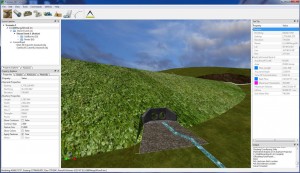
New stormwater system design tool --  Carlson Precision 3D-Culverts

Once a digital terrain model from CAD, Google Earth, or other source is imported, the on-screen image accurately reflects the materials represented, such as roadways, embankments, rocks, fields, etc.

Other innovations in the software include the ability to:

  • Grade surfaces for both upstream and downstream designs;
  • Delineate drainage and ponding areas;
  • Determine peak flow automatically from CN and C factors and terrain;Revolutionize your stormwater system designs with Carlson Precision 3D-Culverts
  • Size culverts and place at low points;
  • Choose from multiple barrel options;
  • Output PDF reports for any selected culvert pipes having flow and headwater across multiple storm events; and
  • Use for retention pond design and pond dewatering.

Carlson Precision 3D Design-Culverts is made to integrate easily into Carlson engineering software, Carlson Civil and Carlson Hydrology. It is also made to work with AutoCAD® and MicroStation® software applications.


Thank You for A Great 2014!

That CAD Girl #1 in Sales of Carlson SoftwareCarlson Software recently let me know that – for the 5th year in a row!! – That CAD Girl was #1 in sales of their desktop products!

I owe a huge “Thank You” to my current customers who come back to me for additional purchases and for passing my name along to others because I know I couldn’t do this without you.

The best compliments I receive are your referrals and I look forward to working with you in 2015 and beyond.


March, April & May Webinars – Now Posted!

I’ve just updated my list of Upcoming Webinars for the next few months. There are several new and reconfigured sessions and I’ve got Mark Long, Carlson’s Hydrology expert, on board to show a lot of the design capabilities in Carlson Hydrology in March. Mark’s the best and I think you’ll get a lot out of his training.

A couple other classes are on the list because you asked for them! They’re narrowly focused classes on very specific topics: Carlson AnnotationSurfaces and Breaklines and Working with Paper Space, Sheet Set Manager and Creating Custom Title Blocks. You’ll have ample opportunity to ask questions and start using what you learn right away!

Here’s the link to pre-register and, if you’re not eligible to attend for free, here is the link where you can purchase a year’s access to the webinars.


It’s Trade Show Season – Come See Me!

It’s trade show season again and I am happy to get the chance to go visit old friends and meet new ones over the next few months…

Next one upcoming is the SAMSOG Technical Seminar in Atlanta later this week. I appreciate the opportunity to present my classes to this group for the first time and I understand it’s going to be quite a crowd; but they take walk-ins on the day of the event. I’ll be covering Tips & Tricks in CAD and Carlson and an Introduction to Field to Finish.

Next will be the NJ SurvCon in Atlantic City which starts on 2/4. I think this is my third year and I really enjoy seeing everyone although they all tell me I talk funny! Again, it’s Tips & Tricks but I’ll also be presenting How to Take a Project from Field to Finish with Carlson Survey.

February 11th thru 13th I’ll be in Columbus, Ohio for the 40th Anniversary of PLSO’s Annual Conference. I’ll be in the exhibit hall for most of the time but on Friday will be teaching CAD & Carlson Tips & Tricks. Make sure you visit my booth and see how your CAD skills match up to surveyors in other states!

And, lastly (I think), I’ll be in Murfreesboro TN at the TAPS 47th Annual Meeting & Exhibition from March 12-14. I’ll be in the exhibit hall most of the time but will also be teaching Field to Finish for Survey and GIS Collection from a GIS Dummy on Thursday March 12th.

It’s not a trade show but don’t forget Carlson’s 2015 User Conference at the end of April. I’ll definitely be there since it’s practically in the backyard of my hometown in Kentucky.

Looking forward to seeing everyone!


12 Months of Webinars Now Available for Purchase

About a year ago I announced that, to ease the amount of time I was spending with each of my customers in online training, I would start presenting live, interactive webinars each month and include those with each new purchase of Carlson Software. It took me awhile to play with the topics and length of time for each webinar but think I’ve finally settled on a good combination and a formula I can live with down the road.

I thought it would be too much work to provide documentation of attendance but I was able to find a fairly easy way to do so and have been sending emails stating the topics and time each person was logged in and active in the webinar. This is no guarantee of getting PDH credit for the sessions, but it probably does allow some of you to rack up the hours through the year.

My biggest problem has been trying to cram way too much information into each session. So I’ve started breaking up the material and am trying to keep each webinar to around an hour. You can see the list of upcoming webinars here and will notice I’ve got 3-4 webinars planned per month. Some months there may be more than that but I doubt there will be fewer than 3 unless something unforeseen comes up and I have to reschedule a session one month. It’s also likely I’ll add some last minute sessions. I’ve had a tentative list of webinars posted for February 2015 for awhile but just confirmed that I’ll have Dean Goodman (of C & G and Carlson Software) presenting a SurvNet Least Squares webinar on February 19th.

Another good/bad problem I hadn’t anticipated was that there would be some folks who stumbled along my website and training after they’d purchased the software but who wanted to be able to attend the webinars. Now that I’ve got a year of them under my belt and I know what I’m able to offer, I have decided to make the webinars available for purchase to those who don’t need to buy the software.

Through 12/31 you can purchase 12 months (including any partial month) of access to the webinars for $995. After 12/31 the price will be $1,295. You can purchase and read more details here in the online store. This will give you approximately 36 hours of training through the year.

Also, if you purchase a new license of Carlson Software directly from me within 6 months of purchasing access to the webinars, I will apply 30% of price you paid for the webinars toward your new software purchase.

Sorry for all the fine print but I’m trying to make it fair to you and me both!


Free Carlson Webinars – Everyone Is Eligible to Attend In December!

Last December I announced that I planned to start including 12 months access to a variety of free, interactive training webinars with all new purchases Carlson Software. Read all the way to the bottom to see how to attend even if you didn’t purchase from me recently…

My intent in offering this training was two-fold: 1) I had gotten to a point where I had too many requests for beginning Carlson training from too many people to be able to handle it all myself so I needed a way to get the training to more people at one time and 2) to continue making sure that, if you purchase software from me, the tools and training you need to get started are available to you. After all, what’s the good of purchasing new software if you are never shown how to use it?

I’ve had to adjust the timing and format a bit in order to make sure I’m able to cover all the material the way I want to. I think at first it was just one webinar per month but each one got longer and longer (up to 3 hours!) as I was trying to cram everything you needed to know about each program into each session. I’ve finally determined that 3-4 roughly hour-long webinars each month on various topics seems to work best. Then, of course, just as soon as I thought I had it all figured out one of my customers registered a mild complaint that all the sessions were during the day when he, a land surveyor, is in the field. That’s a valid point. So, in January I’ve added a 5th hour at 6:00 pm ET to see what kind of response I get. I won’t guarantee there’ll be too many of these but I’m willing to offer it and try. You can find the upcoming list of webinars here.

At this time the only way to get access to the webinars is if you purchase a new license of software from me. Have I mentioned I’ve got GREAT! year-end specials? Also, in some cases, upgrades or maintenance renewal may qualify you to attend.

However, keep watching this space for an announcement in the next week or so about how you can purchase a year’s access to the webinars in case you’re at a point where you need/want the training but don’t need new software. This is in response to a few dozen requests I’ve had through the year requesting access even though they didn’t purchase software from me recently.

In the meantime and in the spirit of Christmas, if you’re considering purchasing or have already purchased from another dealer, please feel free to pre-register and attend one of our December webinars for free as a way to check it out and see if it’s something you’ll find beneficial. “Seating” is limited and clients who have purchased from me in the last 12-month will get first refusal but we’d love to have you join us.


Carlson (and my) End-of-Year Specials are Here!

I’m a few days late in posting this but Carlson has announced their end-of-year CAD pricing specials for 2014.

So, what’s on the shelf? For desktop software we have specials on:


All software purchases include 12 months of access to my live, interactive webinars. These are exclusive training sessions that are not publicly posted online and I’m currently scheduling approximately 3-4 hours per month on various topics. This is my way to help as many of my customers as possible use your software and keep it from becoming shelf-ware!

But, that’s not all!

I also have additional discounts on new purchases of Carlson Survey, Civil, Hydrology, GIS, Takeoff Suite, Construction, CADNet, Trench & GeoTech with Maintenance. These links go to my online store where you can see my standard discounts but I’m not allowed to advertise the super-duper special pricing. You’ll have to email me or Request A Custom Proposal to find out details…

Both Carlson’s specials and the ones I’m running on my own will expire on 12/31/2014…


Google Earth/KMZ Overlays: Flood Zones, State Plane and UTM Zones

Google Earth KMZ file of State Plane NAD 83 Zones


A CAD/Carlson Software buddy – Dent Cermak – passed along a response from FEMA to questions regarding the features available on FIRM maps. The FEMA rep recommended using National Flood Hazard Layer data to view flood data overlays on aerial, street and other imagery. The NFHL data is available  via an online viewer here: http://fema.maps.arcgis.com/home/webmap/viewer.html?webmap=cbe088e7c8704464aa0fc34eb99e7f30.

Another way to access the NFHL data is to download it as a KMZ file that can be opened in Google Earth: https://hazards.fema.gov/femaportal/wps/portal/NFHLWMSkmzdownload.

So, I thought this was pretty cool and when I asked for Dent’s permission to share on my website, he passed along a couple more .kmz files that were even more cool! These are courtesy of Ladd Nelson at Carlson Software.

If you have Google Earth installed on your computer, you only have to double-click to open these files in Google Earth.

KMZ file with US State Plane NAD83 Zones overlay – ZIP file

KMZ file with UTM Zones overlay – ZIP file