That CAD Girl named as certified trainer for the expanded Carlson College
Carlson Software Expands Carlson College
Carlson Connection Launches
Carlson Connection launched on April 1st and is the new online community for anyone using or evaluating Carlson Software. This uniquely collaborative community brings together users, consultants and resellers along with many Carlson staff including sales, technical support and programming.
Check out www.carlsonconnection.com for the latest news, updates and discussion.
How Does Carlson Support Their Users? Ask David Farina
I’m going to post a LONG email stream between one of my clients, David Farina, Bruce Carlson and Dave Carlson. You can see the new feature that David requested and Bruce and Dave’s responses. David received a “development” version of the new features approximately a week after submitting this request.
I asked him for a statement describing his experience with Carlson:
Recently I found that the Time of Concentration input boxes were inadequate under the hydrology portion of Carlson Civil Suite so I emailed a description of the problem to them. I was very impressed to get a phone call the same day. They discussed the problem with me and had a revised program update to me in under a week. I’ve been emailing Autodesk for over a year on problems with Civil 3D and never heard a peep. Needless to say I’m very happy with the customer service I have received from Carlson thus far.
Here is the original question from David Farina on March 4, 2009:
Jennifer,
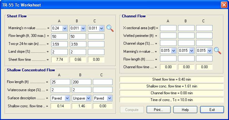
I was going through a mock project to learn the hydrology part of Carlson and noticed a critical deficiency in Time of Concentration input. The review agencies around here want to see the TR-55 method. First, the TR 55 minimum sheet flow needs to be 100’ instead of 300’. They recently changed it per the TR-55 Web site. Second, I don’t think I’ve ever had a project where you didn’t have to split one of these flow types into 2 or more mannings roughness areas.
For example: a flow path that starts on dense grass for 50’ then passes over asphalt for 75’ and back to grass for 200’ would need to be calculated as follows:
Sheet flow 50’ Grass -> Sheet flow 50’ Asphalt -> Shallow Concentrated flow 25’ Paved -> Shallow Concentrated flow 200’ UnPaved.
But as you can see the Carlson input only allows for one entry per flow type.
Below is the Intellisolve version: Notice the A, B C
There is a 5.1 minute difference in TC results which results in a 2 CFS difference in the 100yr example below:
If the above example is that different then I am also concerned about how the Time to inlet is calculated in the example below:
Was the SCS method used to get the 7.1 min value?
Notice the 7.5 value in the TC dialog to the right.
This was the value if I SELECT FLOW LINE FROM SCREEN and pick the path that the dialog on the left generates.
Can I generate a report of how the time to inlet was calculated?
Maybe there can be a button next to the Time to inlet to select TR-55
Maybe Mannings coefficients can also be put into the WATERSHED->DEFINE RUNOFF LAYERS to be used for this calc as the flow path passes through each polyline area the same way Carlson already calculates the composite CN.

Will any of this matter if we get HydroCAD and link it to Carlson?
Just food for thought.
Thank You,
David Farina
Senior Designer


I forwarded David’s question onto Bruce Carlson, President of Carlson Software, and Dave Carlson, Director of Programming, and received this response from Bruce:
Folks: Excellent input—this will find its way into the next release for sure. We’ve spent a lot of time studying Haested and matching numbers there on pipe flows in culverts, for example, covering all conditions—but do need to put to bed Time of Concentration for approved defaults and sub-catchment conditions as they vary within a watershed area. This Intellisolve example is really helpful. Also, I took in input at Jennifer’s Statesville, NC presentation Dec. 2007 that mentioned the new 100’ default and also mentioned:
Using Q=CIA, there are new “rules” being published that using larger pipes or it may be larger drainage areas, there is an added multiplier in the form Q=CIA*Q1 where Q1 is a table of values. I didn’t get the full details, but we need to research this.
And in storm sewer design, if we are compositing the calc of time to inlet using a “short-form” SCS-style method, based on percentage area of various land uses and associated runoff coefficients, we need to have a Report button that documents the results for full vetting and reporting out by users, and we need to incorporate an additional auto-calculated, long-form TR55 time of concentration there as well that uses sheet flow, channel flow and shallow concentrated flow. One key in all this is to be able to auto-distinguish these flow types from the DTM and land uses and have the forms filled out with default values, which the user can change.
Question I’m curious about. Say you built a gentle 6’wide, 1% slope swale with 6:1 side slopes, hardly noticeable, mowable, between lots in a subdivision. Would the flow in that be treated as shallow concentrated flow or channel flow? When would one condition end and another begin, by definition, so we can get real precise on auto-calculating these using layers/land use types and DTM values?
Good stuff, and it will get done.
Bruce Carlson, PE
Pres., Carlson Software
David added the following:
I think when to use channel flow should be determined by the width of the bottom of the channel and hence how deep the channel gets on an 2yr storm 24 storm.
You could have a channel with 1:1 side slopes but if the bottom was 50’ wide and the flow path started in the channel then
the first 100’ would still be sheet flow in my book. Unless of course a huge amount of water was entering the channel from another basin.
I think the concentrated and channel flow times (being in the fraction of a minute range) are so small and have such a small impact on overall time
compared to sheet flow (fraction of an hour) that you could pick an arbitrary number like 5’ wide bottom and smaller is channel flow and not upset the model.
Sheet flow probably makes up 80 to 90 % of overall TC if it is over grass.
Anyone disagree?
Thank You
Dave Carlson sent this on March 11, 2009
Hi David,
Here’s an update to the Tc by TR-55 routine that allows unlimited number of breakouts. This update is for Carlson 2009 on Acad 2007-09. To install, unzip and copy the arx to the Carlson2009LSP folder. Let me know if you need a different version or have more suggestions.
For the Storm Sewer Network routine, I put it on the to-do list to add a Select button next to the Tc to show the components that make up the Tc like the Select button does for CN. Also we will looks at adding Manning’s n to the Define Runoff Layers for use with Tc calcs.
Thanks for the input.
Dave
Originally posted on Carlson Connection by Jennifer Dibona
Coming in Carlson 2010
I’m not privy to the “official” list of coming updates, but I can share a few things that I know will be in the next release. Most of these come from “wishlist” items I have submitted on behalf of my clients.
The folks at Carlson are welcome to add their 2-cents in the Comments of this post or on Direct From Carlson.
Option for placing building footprint a distance off the building setback line.
Currently, the LotNet command places the building footprint exactly on the midpoint of the building setback line. We heard the request several times to have the option of placing the footprint some distance behind the setback line. It will be in the 2010 release.
C & G Survey
Instead of having two separate survey programs, Carlson will be incorporating C & G as a separate set of menus in Carlson Survey in 2010.
Basic IntelliCAD Menu
If you’re running Carlson on top of an AutoCAD-based program, you have an icon or menu option to switch over to an AutoCAD menu that has basic Draw commands such as line, pline and text and basic Modify commands such as copy, explode and pedit. Although it’s not easy to get to right now, IntelliCAD has a similar set of menus and toolbars. Carlson 2010 stand-alone with IntelliCAD will have a menu item and toolbar icon allowing you to easily switch over to the IntelliCAD menus and then back again to the Carlson menus.
Lookup table of curb slopes for super-elevation transitioning
This new feature will handle curb transitions like those shown in this NC DOT detail drawing.
Originally posted on Carlson Connection by Jennifer Dibona
Poll Question 3/30/2009
[polldaddy poll=1493826]
Originally posted on Carlson Connection by Jennifer Dibona
AutoCAD 2010 Release, Autodesk 2006 Software Retirement
Autodesk has announced that their 2010 products will be released on March 24, 2009. I found this post by Randy McSwain to be a good overview of the new features in AutoCAD 2010.
As of March 13, 2009, Autodesk no longer supports or offers upgrades from their 2006 products.
Because of the retirement of Land Desktop, I see that Autodesk is offering to crossgrade existing Land Desktop customers to Map or Civil 3D with special pricing. Subscription will probably be mandatory, but I’m not certain.
Originally posted on Carlson Connection by Jennifer Dibona
IntelliCAD Update for Carlson Products – 2/2/2009
The most recent IntelliCAD Update for Carlson can be found here:
http://update.carlsonsw.com/entov/c2009_icad_post65_install.exe
From Carlson:
It contains the fixes based on user input and crash submissions since we released 6.5.
In particular, the following features and crashes has been addressed or at least a fix has been attempted:
1) Crash on mouse move
2) Crash on save (during exit?)
3) Another update to image engine to correct problems in the last update
4) Crash during printing or redraw after real time zoom
5) Numerous “small” crashes
6) Crashes during drawing opening or saving
7) Right click menu is added for entity modifications ( this requires menu reload and will reset the menus and toolbars). To reload the menu, type MENU and select icadbase.mnu file.
8) Slow autosave/save has been addressed or at least improved.
9) Font mapping problems have been addressedIn case if this patch makes matters worse for you, the older patch is available here: http://update.carlsonsw.com/entov/c2009_icad_6_6_17_41_install.exe . Simply run it to restore to the last version.
Originally posted on Carlson Connection by Jennifer Dibona
Dewberry Case Study, ‘Choosing and Implementing Carlson,’ at the Carlson ‘Break New Ground’ Users Conference, April 5-7
MAYSVILLE, Ky., U.S.A. (March 24, 2009) ― At the Carlson “Break New Ground” User Conference in Lexington, Ky., April 5 through 7, David Palumbo of Dewberry will be presenting a case study on how the 2000-person professional services firm with more than 40 locations in 18 states recently chose the Carlson Civil Suite for its site-civil engineering needs.
“In April 2007, Dewberry’s site-civil market segment group embarked on a strategic initiative to unify and modernize site-civil work flow across two dozen offices that service this segment,” said Palumbo, PE, Technology Manager for Infrastructure Services at Dewberry. “Carlson Civil Suite was selected over two competing solutions as best aligning with Dewberry’s desired work flow and site-civil technical specifications.”
The Carlson Civil Suite includes Carlson Civil, Carlson Survey, Carlson Hydrology, and Carlson GIS. Together, these four products are a comprehensive set of design/drafting tools that automate all facets of the civil engineering project.
Palumbo, whose duties include facilitating technology solution acquisition and implementation for all of Dewberry’s infrastructure services, including site-civil, transportation, and telecommunications, will explain the intensive process Dewberry performed to choose Carlson. Then he will show how Dewberry, an Engineering News-Record “Top 50” design firm, set about to most effectively implement Carlson throughout their extensive company.
“We will have approximately 250 to 300 users of the product when we’re done,” he said, noting that the project started by first defining a comprehensive work flow and site-civil task specification independent of software and automation tools. It was these specifications that became the basis of evaluating vendor solutions.
Palumbo will be joining Robert H. (Rob) Campbell, president and CEO of Juniper Systems, Inc., and Brent Jones, PE, PLS, of ESRI, as a speaker at Carlson’s 2nd annual conference designed specifically for surveyors, civil engineers, mining engineers, construction engineers, partner manufacturers, and dealers. Palumbo will be speaking during the Monday evening banquet.
“Working with Dewberry has been a rewarding experience,” said Bruce Carlson, president and founder of Carlson Software. “With so many offices, Dewberry had special demands for data sharing and project tracking and also wide-ranging needs for data interoperability across platforms such as AutoCAD, Microstation and ESRI, including compatibility with field data collection and instrumentation,” he added. “Our product offerings are focusing on these capabilities. We enjoyed being a part of their competitive product review – that’s our preferred business environment!”
The goal of Carlson’s user conference is to help users “break new ground” and learn how to optimize the power of Carlson’s versatile software. Learning tracks at this two-and-a-half-day event will cover the same land development aspects as Carlson Software products: data collection, land surveying, civil engineering, mining and construction and machine control.
Carlson is keeping the cost of the two-day event at $695 right up to registration to help more people harness the power of Carlson Software and get project ready. Sign up now at www.carlsonsw.com/conference. Group discounts are available.
About Carlson Software. Carlson Software, an independent company founded in 1983, develops software solutions to bring the land development professional from concept to completion. The 25-year-old company is well known for its comprehensive civil, surveying, machine control and positioning, plus mining software solutions. Its free technical support and dedication to customer service is unique in the industry. Carlson Software is headquartered in Maysville, Ky., with branch offices in Boston, Atlanta, and Queensland, Australia.
About Dewberry
Dewberry is a 2,000-person professional services firm, specializing in engineering and architectural design; program management; planning; GIS; surveying; and environmental services. Established in 1956, the firm has more than 40 locations nationwide, with headquarters in Fairfax, Virginia, near Washington, DC. For more information, visit www.dewberry.com.
Originally posted on Carlson Connection by Jim Reinbold
Large Companies DO Use Carlson – Dewberry Presenting Implementation Case Study at Conference
Carlson Software put out a press release this week announcing that a representative of Dewberry will be making a presentation at the User Conference about their recent implementation of Carlson Survey and Civil Software.
This is a good supporting argument for my Myth #7 about how large companies DO use Carlson.
Click here for the press release about Dewberry.
Originally posted on Carlson Connection by Jennifer Dibona
BIM this, BIM that… What is BIM?
Q: What is BIM? And, exactly how does it relate to the civil engineering industry?
A: BIM, by definition, has nothing to do with civil engineering.
BIM stands for “Building Information Modeling”. The term “BIM” originated in the Architectural world and, generally, defines the process of inputting information to and extracting information from a 3D model of a building/facility.
Definition of BIM from the National BIM Standard:
BIM is best thought of as “a digital representation of physical and functional characteristics of a facility…and a shared knowledge resource for information about a facility forming a reliable basis for decisions during its life-cycle; defined as existing from earliest conception to demolition.”
From the National Institute of Building Sciences:
Building Information Modeling (BIM) refers to the use of the concepts and practices of open and interoperable information exchanges, emerging technologies, new business structures and influencing the re-engineering of processes in ways that dramatically reduce multiple forms of waste in the building industry. The National BIM Standard, a key element of the overall industry transformation being supported and coordinated by the buildingSMART alliance™, establishes standard definitions for building information exchanges to support critical business decisions. Implemented in software, the consensus-based standard will form a basis for more accurate and efficient commerce within the capital facilities industry. The National BIM Standard is also intended to help participants in facilities-related processes achieve more reliable outcomes from commercial agreements.
From Geomatics International:
A Building Information Model (BIM) is a digital representation of physical and functional characteristics of a building. Construction and management of buildings involves many stakeholders, so that proper sharing of information over the entire lifecycle of a building is very important. The Open Geospatial Consortium (OGC) is developing BIM standards that promote efficient web-based information sharing in the Architectural, Engineering, Construction and building Ownership and Operation (AECOO) markets.
Because Wikipedia is open-source and able to be edited by anyone and everyone, the entry for BIM changes regularly. The entire entry looked like this as of February 26, 2009. Here is an excerpt:
Building Information Modeling (BIM) is the process of generating and managing building data during its life cycle[1]. Typically it uses three-dimensional, real-time, dynamic building modeling software to increase productivity in building design and construction.[2] The process produces the Building Information Model (also abbreviated BIM), which encompasses building geometry, spatial relationships, geographic information, and quantities and properties of building components.
A lot of confusion is now occurring because Autodesk and their civil resellers are trying to make the connection between BIM and Civil or, more specifically, Civil 3D. See examples here:
BIM for Civil Engineers by Sanjay Asnani, Autodesk
If link doesn’t work, find this document HERE.What Does BIM Mean for Civil Engineers? by Adam Strafaci, Autodesk
Civil 3D and BIM… How do they relate? by Melanie Santer, US CAD
However, if you simply Google “bim building information modeling” and look at the first two pages of returns, the only entries that attempt to connect BIM and civil engineering belong to Autodesk or one of their civil resellers. All other hits refer to BIM in an architectural/building sense. If there is a specific software program mentioned, it is Autodesk’s Revit product. A caveat to this is the civil/structural engineering specialty field of bridge construction which can also be modeled using Revit. Bridge construction is a bit of a hybrid in that it is similar to building design and can also legitimately be related to BIM.
Among Autodesk’s architectural team and resellers, most, if not all, references to BIM are solely in an architectural/building capacity. See examples here (pages were cached on 2/26/09):
As you can see from the above links, it is technically incorrect to connect BIM and Civil. However, many in the civil world are witnessing the Autodesk definition of BIM take hold. So, in the event you are ever asked or required to “BIM” a civil project, you are essentially being asked to design and deliver a dynamic, 3d model of the entire project.
It is important to realize that creating a dynamic 3d model for a Civil project (or “BIM”ing a civil project) is not limited to using a particular software program.
Find a civil engineering design software that allows you to design to specific criteria, is able to show a great visual representation of all the components of your project in 3D view and is able to dynamically reflect changes and you can “BIM” along with the rest of the world.
Designing a project using a dynamic model allows you to design according to specific criteria such as AASHTO (American Association of State Highway and Transportation Officials) standards or by specifying minimum/maximum values for storm or sanitary sewer design. It also is invaluable to detect, before construction, potential conflicts between a proposed network of roads and associated utility networks. As an example, a dynamic 3d model would trigger a warning if, when lowering a roadway, the rule for minimum cover over a pipe on an adjacent roadway has been violated. Also, creating this model allows you to view the model, make changes to vertical alignments and see dynamically updated cut/fill quantities all at once.
To reduce the confusion, it might be time to coin a new term such as “Site Information Modeling” to describe the process in the Civil industry. But, there is still quite a disparity between the “Information Modeling” done for a Building compared to that done for a Civil project. In true BIM, the “I” (Information) component is as important as the “M” (Modeling) component because determining usability and functionality of the Building through its lifecycle is one of the goals of BIM. At this time, the process on the Civil side is still much more about the “Model” and not nearly so much about the “Information” going into and coming out of the model. When we are able to incorporate results of traffic flow analyses for a roadway or inspection reports showing sludge build-up and flow capacities in sewer/storm pipies and manholes, we will be truly using the “Information” as it was intended in an “Information Model”.
Originally posted on Carlson Connection by Jennifer Dibona