Picks and Clicks: Dynamic Blocks

This article originally appeared in the December 2010  issue of Professional Surveyor magazine.

Welcome to the first installment of this new column highlighting favorite AutoDesk, IntelliCAD, and Carlson Software features. My goal is to help you reduce your number of  “picks and clicks” while using these pieces of software so you can be more efficient, saving time and money.

Because many of us are hanging onto our current software versions for as long as possible these days, I will try to avoid reviewing features that were released in “last week’s” version and will instead write about commands and features that have been around for at least a few years.

First: A little about my background and experience. My first CAD class was with AutoCAD 9 and DCA software as part of my Surveying Technology coursework in college. After graduating, I worked for various consulting, engineering, and surveying companies where I used mostly the Autodesk family of products: AutoCAD, AutoCAD Map, Land Desktop, and Civil Design with brief detours into the MicroStation, GeoPak and Eagle Point worlds.

It was during this time that I started teaching basic CAD and civil/survey CAD classes at local community colleges. I then joined a local Autodesk and Carlson Software reseller to help start and build their training division. In 2004 I stepped out to begin working for myself as That CAD Girl. I offer Carlson Software sales; training and support for Autodesk, Carlson and IntelliCAD; and associated consulting services while specializing in CAD standards development and surface modeling training. My website is at www.thatcadgirl.com. And my surveying column is now here!


Water Valve

(Figure A)

One of my favorite, fairly new AutoCAD features is Dynamic Blocks, which was first introduced in AutoCAD 2006. A Dynamic Block is simply a standard block that has been enhanced with additional functionality. You may have seen examples of complex Dynamic Blocks that allow you to change the size (by stretching) or the orientation (by mirroring) only pieces of a block without having to EXPLODE it. But, you can also save many picks and clicks by giving your existing blocks a facelift with some simple Dynamic functionality. Let’s start with a standard symbol or block that 
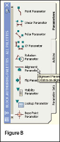
most everyone will already have saved in a block library somewhere: a Water Valve.

To use the standard version of this block in a drawing, we usually have to:

  1. Use the INSERT command to bring the block into the drawing.
  2. Use a NEArest OSNAP to position the block on a line representing a waterline.
  3. Use the ROTATE command with the Reference option to align the block with the line.
  4. Whew!

Two minutes (or less) in the Block Editor will eliminate steps 2-4 (at right.)

  1. Insert the standard Water Valve block into your current drawing.
  2. Left-click to select the block.
  3. Right-click and open the Block Editor from the shortcut menu.
  4. On the “Parameters” tab of the Block Authoring Palette, select the tool to create an Alignment Parameter. [Figure B]
  5. The Command: line prompts you to, “Specify base point of alignment or [Name]:”. Use your INTersection OSNAP to specify the insertion point for the block.
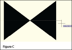
  6. Next, you are prompted to “Specify alignment direction or alignment type [Type] <Type>:”.  [Figure C]  Turn Ortho On and pick a point directly to the right of the insertion point.

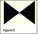
  7. When finished, the block with its new Alignment icon will look like this in the Block Editor: [Figure D]
  8. 
Pick the Close Block Editor button at the top of the screen and then pick “Yes” when prompted to save the block definition.


Using the Dynamic Block

Once you are back in the main drawing screen, the original instance of the block will have been updated.

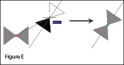
  1. Left-click the block to see the new Alignment icon.
  2. Left-click on the blue Alignment icon. This allows you to “pick up” the block and move it. [Figure E]
  3. Drag the block on top of a line in your drawing that represents a waterline. You will notice that, once your crosshairs are positioned over the line, the block automatically aligns itself to the line, and, in addition, the NEArest OSNAP is enabled allowing you to position and snap the block directly onto the line.
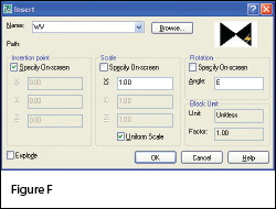
  4. Use the Insert command to draw additional copies of the block into the drawing. Notice that the thumbnail image of blocks with Dynamic parameters displays a lightning bolt icon so as to differentiate Dynamic Blocks from standard blocks. [Figure F]
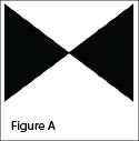
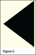
Waterline Reducer

[Figure G]

Another often-used water-utility symbol that can benefit from the addition of Dynamic properties is the waterline Reducer. This symbol is used to indicate a change in the size of a waterline. In addition to an Alignment Parameter, this symbol needs a Flip Parameter that allows us to easily mirror it to change its direction. Unlike an Alignment Parameter, adding a Flip Parameter to a block also requires that you add a second Dynamic Block component called an Action. Giving a block “flip-ability” requires a few more steps, but is still rather easy.

  1. Repeat steps 1-7 as described for the Water Valve to insert the “Reducer” block into the drawing and add an Alignment Parameter to it. 
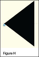
The Reducer with its Alignment icon is shown at left: [Figure H]
  2. Turn Ortho On.
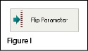
  3. Pick the Flip Parameter icon on the Block Authoring Palette. [Figure I]
  4. The Command: line prompts you to “Specify base point of reflection line or [Name/Label/Description/Palette]:”. Use your ENDPoint OSNAP to specify the insertion point for the block (use the same point as for the Alignment Parameter).
  5. The Command: line next prompts you to “Specify endpoint of reflection line:”. With Ortho On, pick a point directly above the “Base Point” specified in the previous step. These two points define the “reflection line” for mirroring.
  6. You are then prompted to “Specify label location:”. Pick a point somewhere just above the Reducer symbol. The label reads, “Flip state”.
  7. Use the MOVE command, with Ortho On, to slide the Flip icon above the block.
  8. The Reducer [Figure J] with its Alignment  [Figure K] and Flip icons  [Figure L]  are shown at right. A Warning icon [Figure M] is also displayed indicating a missing
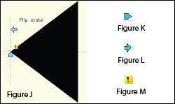
 Action component.
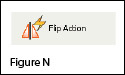
  9. On the “Actions” tab of the Block Authoring Palette, select the tool to create a Flip Action. [Figure N]
  10. The Command: line prompts you to “Select Parameter:”. Select any part of the Flip Parameter including the label, the Flip icon, or the Warning icon.
  11. Next, you are prompted to “Specify selection set for action. Select Objects:”. Select the Flip icon and all entities that make up the block/symbol.
  12. You are then prompted to “Specify action location:”. Pick a point somewhere near the “Flip state” label. The label has a lightning bolt icon and reads, “Flip”.
  13. Pick the Close Block Editor button at the top of the screen and then pick “Yes” when prompted to save the block definition.

Using the Dynamic Block

As before, once you are back in the main drawing screen, the original instance of the block will have been updated.

  1. Left-click the block to seea the new Alignment and Flip icons.
  2. Left-click on the blue Alignment icon to move it onto a line representing a waterline.
  3. Left-click on the blue Flip icon to mirror the block along the line.
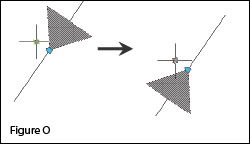
  4. Use the Insert command to draw additional copies of the block into the drawing. [Figure O]

Note that the steps change the block definition in the current drawing only. The WBLOCK command must be used to save the block out as an external Drawing (.dwg) file.

This article originally appeared in the December 2010 issue of Professional Surveyor magazine.


What is Carlson up to?

This is a good article about Bruce Carlson and where Carlson Software is planning to go in the future…

Independence All the Way

Originally posted on Carlson Connection by Jennifer Dibona


BIM is not GIS

As someone quite entrenched in both disciplines (Civil and Architectural), I’ll add my 2 cents worth on the BIM vs. GIS subject.

In my opinion, BIM and GIS are both “methodologies” rather than “products”. The acronyms each have their own meaning and refer to designing, building, and managing information in a full life-cycle.

Each discipline has its own standards; from CAD standards to design standards (think of AIA vs. AASHTO), but both BIM and GIS rely on correct As-Built data to provide accurate information about their models.

BIM
The National BIM standard states the definition of BIM as:

BIM is best thought of as a digital representation of physical and functional characteristics of a facility…and a shared knowledge resource for information about a facility forming a reliable basis for decisions during its life-cycle; defined as existing from earliest conception to demolition.”

Autodesk has taken the BIM acronym that has provided a great deal of success with their Architectural Modelling packages and applied it to their Civil products as well. Their logic appears to be that its a “3D” product, therefore it is a “BIM” product. I believe that it is irresponsible to change terminology to simply advance product sales.

On the Autodesk Web Site, Autodesk lists a number of products as being “BIM” products:

  • Revit
  • Navisworks
  • Design Review
  • AutoCAD LT
  • + several more

With the acronym meaning Building Information Modelling (with building being a verb OR a noun), its interesting to see products such as AutoCAD LT and Design Review being shown on the list.

Revit
Revit is a Design Tool that allows the storage of certain pieces of information as well as the ability to add custom fields (heating capacity, cooling capacity, etc.) to the actual objects.

Navisworks
Navisworks integrates information from multiple data sources to provide a cohesive collection of information (graphics and data) to analyze things such as clash detection (HVAC duct work clashing with structural components, etc.).

AutoCAD LT
AutoCAD LT is Autodesk’s low-end design package. Apparently, any DWG file creation tool is now a BIM product as well.

Design Review
Design Review is a light-weight DWF viewer and markup tool. While it has been used as a backbone of products such as FMDesktop, its neither a Design tool, nor a Modelling tool.

FMDesktop
Absent from the list is FMDesktop. FMDesktop was one of Autodesk’s tools for managing the Building Information and Autodesk just dropped the product (Note: There are dozens of Facilities Managent Products available that provide similar capabilities such as FM:Systems, Archibus, Tririga, Manhattan, Cadapult, Famis, and more).

In the 2006 – 2007 time frame (when Autodesk acquired FMDesktop), Autodesk themselves showed customers Power Point slides regarding BIM. These slides showed where the “Design”, “Build”, and then “Operate and Manage” processes were performed. FMDesktop was Autodesk’s solution to tell the story of the building lifecycle and where the information was to be managed. These were broken down into 2 sections: The “Data Collection” piece and the FMDesktop piece.

Data Collection incorporated the Design (several disciplines such as Architects, MEP Systems Engineers, and Structural Engineers) as well as the majority of the Build process. The FMDesktop piece overlapped the Build process and then took over for the “Operate and Manage” process.

In my opinion, building that model of information AND managing that information is the true test of a “BIM” solution. There is no 1 product that is a “BIM” product. Its a series of technologies that are incorporated to provide the “information”.

Ultimately, a database component is required to work with the graphical representation of data (which certainly could be referred to as the “Building Model”).

GIS
GIS is BIM’s counterpart whereby Geographic (position on the planet) information is being stored and managed.

Most end users might think of GIS solutions as Google Maps or Google Earth where they can enter an address and out pops a graphic representation of that location or directions on how to get there. The graphic is just the tip of the iceberg. Without the data, the graphic would simply be a pretty picture.

Just as with BIM data, GIS data utilizes design tools to build the graphics and As-Built data and then tools to expand upon the As-Built information.

While there are a number of individual products on the market to assist in the creation, manipulation and distribution of GIS data, a complete GIS system involves more than 1 product or techonology.

A couple of the common Design Products are: Autodesk Civil 3D and Carlson Civil Suite

AutoCAD Civil 3D
Civil 3D is an object-oriented design tool for Civil Engineering applications. Because the tool is object oriented, the end product is not easily distributable. The data can be transferred to other links in the GIS solution chain by using technologies such as LandXML, but the graphical interaction is lost in this process (i.e. the objects are lost).

Carlson Civil Suite
Carlson’s Civil products work with DWG files in an AutoCAD or IntelliCAD DWG format. Because the data is stored as compatible DWG information with external data files, the data is easily transferred to other products in the GIS solution chain.

Managing the data developed in the design process is the next component of the GIS life-cycle. A number of products provide those solutions: ESRI ArcGIS, Vueworks, and Custom Mapguide Solutions.

ESRI ArcGIS
ESRI’s shp (shape) and adn (coverage) files are quite possibly the most prevalent GIS specific data files available and are often integrated in GIS solutions. ArcGIS allows GIS solutions to be deployed similar to FM solutions in the BIM world.

Vueworks
Vueworks is an organization that builds GIS and Work Management solutions using the ESRI base applications.

MapGuide
MapGuide is Autodesk’s development environment to build GIS applications. It is often used in concert with ESRI, Microstation and Autodesk data files.

GIS Standard
While there is not yet a concensus on a singular GIS standard, there are independent Spatial Data Standards employed by each digester of GIS data. You can view some of those here:

Both GIS and BIM perform very specific functions in accordance with their own disciplines. While the terminology is often mis-used, they refer to unique information systems; BIM in the structural facility world and GIS in the geographic world.

Originally posted on Carlson Connection by Jon Luby


Top Myths About Carlson Software

I’m asked many of these questions on a fairly regular basis and thought it was time to look into some of them and provide the fullest answer I could. Where possible, I’ve researched and found the answer myself. In a few cases I had to rely on Carlson representatives to supply the answers.
  
Myth #1  Autodesk stopped working with Carlson in February 2008. 
  
 False. In February 2008 Carlson simply stopped being a reseller of Autodesk products.

In other words, if you want to run Carlson on top of AutoCAD, Map, Land Desktop or Civil 3D, you’ll have to buy it from an Autodesk reseller instead of from Carlson. Carlson remains part of Autodesk’s Developer Network (ADN) and is listed on Autodesk’s partner page. The ADN designation provides tools to developers to help build their products on top of Autodesk products. As a point of comparison, Eagle Point Software is also a development partner of Autodesk.
  
 
Myth #2  Carlson is owned by Autodesk or, (“bonus”-myth) Carlson will be sold to another, larger software company. 
  
 False. Carlson Software was started in 1983 by Bruce Carlson and remains a private, family-owned business. No one can absolutely guarantee the future, but I have heard Bruce Carlson speak many times about the value he places on competition in the marketplace and his belief that the consolidation of many other software companies has come at the expense of the end-user of the software.

Selling out? I don’t see it. But partnering? Yes. Carlson places a great deal of value on working with any company who wants to work with them.   Click on the image below to see the many different programs Carlson imports data from and exports data to.

Carlson Import and Export Options

Myth #3  Because Carlson Software uses basic AutoCAD entities instead of “intelligent objects”, it does not have 3D or dynamic abilities. 
  
 False. Carlson Software uses basic AutoCAD entities so that all drawings produced by their programs can be easily shared with any other DWG- or DXF-compatible program, regardless of version. Carlson has figured out a way to have the dynamic reactions work on basic entities such as lines, polylines and text. One example would be having profiles and storm drain structures automatically adjust their elevation as a centerline alignment is edited and changed along a surface. And, all of this happens without having to fight the dreaded “proxy objects”!  
 
Myth #4  Because Carlson now works on top of Intellicad, it no longer works on top of AutoCAD-based products. 
  
 False. Carlson Software has always worked on top of AutoCAD-based products and, if you listen to Bruce Carlson discuss the issue, hopes to always continue doing so.

In April 2008, Carlson began giving their customers an IntelliCAD-based “stand-alone” copy of their software with every purchase of Carlson Civil, Survey, Hydrology, GIS, TakeOff and other programs. (IntelliCAD is widely described as an “AutoCAD-clone”. You can read more HERE.). This, again, gives more power and options to Carlson users because it allows the user to choose whether to run Carlson on top of practically any version of AutoCAD, AutoCAD Map, Land Desktop, Civil 3D or on top of IntelliCAD.

Also, with their Sight Survey program (launched in 2008), Carlson created their first program to run on top of MicroStation.

At last year’s 25th Anniversary users’ conference, Bruce Carlson stated that Carlson hopes to have their software working on 4 different platforms within the next few years: IntelliCAD, AutoCAD, Microstation and ESRI. 
  
 
Myth #5  Carlson doesn’t have CIVIL “BIM”-ability. 
  
 First, the premise of the statement is incorrect. BIM (Building Information Modeling), by definition, has no relationship to the civil engineering industry. It is architectural in scope and refers to actual buildings and facilities.

However, for several reasons there has been a push to re-define the term BIM to apply to Civil Engineering (in general) and Civil 3D (in particular). When discussing BIM in the context of Civil Engineering, it simply means that a software program has the ability to:

  • design to specific criteria
  • show a great visual representation of all the components of your project in 3D view and
  • dynamically reflect changes to your project.

Can Carlson Software do all that? Absolutely.

Carlson can, and has been able to, produce true 3D models of civil/survey/utility project sites for years. These models can be viewed in 3D and quantities are dynamically updated whenever the model changes.

Because Carlson has strongly served the U.S. mining industry for over 20 years, they long ago developed features for grading, material quantity calculations and surface viewing and visualization to meet the demands of this industry. In fact, the civil industry pales in comparison to the mining industry in regard to these demands.  
 
Myth #6  Carlson has only been developing civil software since 2007. 
  
 False. To make sure I got this right, I asked the folks at Carlson for help and received the following in response:

Bruce Carlson began developing his software for the mining industry in 1983. By 1984, the program was able to extract profiles and cross-sections, calculate volumes and design road profiles. 3D Surface viewing abilities have been available in Carlson Software since the early 1990’s.

Carlson developed the stand-alone Carlson Survey program in 1996 and in 1999 Autodesk contracted to market and sell a version of it called “Autodesk Field Survey”. Autodesk did away with Field Survey after a few years and Carlson migrated most users over to Carlson Survey where it has grown to become a favorite of surveyors.

Various civil features were organized as modules in a package called SurvCADD that was released in 1989. The civil engineering routines were renamed as Carlson Civil in 2006.

The first Hydrology module for Carlson was released in 1993. It was re-packaged as Carlson Hydrology in 2006.

Carlson Hydrology was the first and, I believe, is still the only H & H software to function entirely within the DWG-environment. If I learn differently after this document is made public, I will post a correction in this space.
  
 
Myth #7  Carlson may have found a spot in some surveying firms, but larger firms aren’t using it. 
  
 False.  Again, I requested generic customer data from Carlson and was told that,

Among our 30,000+ users, there are many DOT agencies and also ENR Top 50 firms using Carlson Software. Carlson Software is very experienced in working with large firms, due to their mining background. All 20 of the top 20 U.S. coal companies use Carlson Software at some level, most being standardized on the software for mine planning and design.

As far as my personal experience, I’ve only been working with Carlson Software for a couple of years and companies I work with tend to have fewer than 25 users. I can personally say that I have seen or know of a few large firms who have moved to or are in the process of moving to Carlson.

These do not include the many customers of mine who have recently let their software contracts lapse, purchased one or more seats of Carlson and have told me they plan to purchase and implement Carlson when the economy rebounds. 
  
 
Myth #8  Carlson Software does not support the full project lifecycle – Concept to Completion. 
  
 False. I think Carlson probably has the project lifecycle covered better than any other software firm in existence.

Carlson Software has data collection, survey processing, civil design, hydrology, GIS, construction material takeoff and machine control software in their stable. 
  
 
Myth #9  Carlson Software doesn’t have the support system in place to adequately support its users. 
  
 False. Carlson provides free technical support directly out of their Maysville, KY and Boston, MA offices. Again, I have heard Bruce Carlson say that keeping tech support free and in-house ensures that their software will remain easy-to-use and that the company will always be responsive to the wishes of their customers.

If a bug or other problem with the software is encountered and logged into Carlson’s tech support department, the corrected files will be emailed to you as soon as the programmers develop the fix. Periodically a collection of the updated files will be released to all users as a maintenance patch. These updates are available to all users whether or not they are under a maintenance contract with Carlson.

I received this testimonial from a customer on March 13, 2009.

“Recently I found that the Time of Concentration input boxes were inadequate under the hydrology portion of Carlson Civil Suite so I emailed a description of the problem to them. I was very impressed to get a phone call the same day. They discussed the problem with me and had a revised program update to me in under a week. I’ve been emailing Autodesk for over a year on problems with Civil 3D and never heard a peep. Needless to say I’m very happy with the customer service I have received from Carlson thus far.”

David Farina, CCAD Engineering
– Greenville, SC

Other examples of Carlson’s responsiveness:

Example 1: The ability of the Carlson Civil & Hydrology “Design Bench Pond” command to have multiple interior benches was added to the software after an attendee at a workshop I held in Raleigh, NC in December 2007 requested it.

Example 2: In the LotNet command, the prompts asking users to specify minimum and maximum building offset distances for lot layout generated too many tech support calls. In the next release, the prompts were re-worded to make the intent more clear.

Example 3: The LotNet command now allows you to designate “sub-areas” (such as wetlands, stream buffers, poor soils, etc.) to be excluded from your area to be subdivided during the lot layout routine. This request came from a prospect during a demonstration in Raleigh.

Example 4: I understand that Carlson’s tech support team was bombarded by requests to change the default cul-de-sac location from the “Start” of the road to the “End” of the road in the RoadNet command. This was changed in the 2009 release.

Example 5: The ability to draw multiple building pads inside lots during the lot layout routine in LotNet was requested by a firm out of Savannah, GA. 
  
 
Myth #10  Carlson Software can’t share data with Land Desktop or Civil 3D. 
  
 False. Carlson has many tools in their software to import civil/survey data from and export data to Land Desktop and Civil 3D. It can be said that Carlson Software works with Civil 3D data as well as Land Desktop or any other civil/survey software and also works with Land Desktop data as well as Civil 3D or any other software.

Carlson has LandXML import and export functionality, can directly convert Land Desktop points and contours into Carlson points and contours and also imports a Civil 3D surface as elevated contours.

Regardless of the civil/survey software being used, LandXML is the best mechanism to import/export a surface model because it maintains the TIN lines of the surface. 
  
 
Myth #11  To be continued. 
  
 If anyone thinks of other question(s) they’d like to supply, please email me HERE. I’m open to suggestions and don’t mind expanding beyond 10 Myths.

Originally posted on Carlson Connection by Jennifer Dibona