Current Autodesk Promotions – Rebates, Renewals & AutoCAD LT

With the end of perpetual licensing for some/most Autodesk products coming on January 16, 2016, Autodesk is running a few promotions to encourage current users to embrace the switch.

Click here for Autodesk’s Buyer’s Guide or email me to request access to the recording of my recent webinar with an Autodesk reseller and Carlson Software programmers explaining how these changes may affect us going forward.

You will want to touch base with your local Autodesk reseller or, if you don’t currently work with anyone, email me for a recommendation

Some of the promotions include:

  • Discounted purchases of AutoCAD LT
  • Rebates on new seats, maintenance and desktop subscriptions – Ends July 24, 2015
  • Financing options and discounts for multi-year renewals – Ends July 24, 2015


It’s Trade Show Season – Come See Me!

It’s trade show season again and I am happy to get the chance to go visit old friends and meet new ones over the next few months…

Next one upcoming is the SAMSOG Technical Seminar in Atlanta later this week. I appreciate the opportunity to present my classes to this group for the first time and I understand it’s going to be quite a crowd; but they take walk-ins on the day of the event. I’ll be covering Tips & Tricks in CAD and Carlson and an Introduction to Field to Finish.

Next will be the NJ SurvCon in Atlantic City which starts on 2/4. I think this is my third year and I really enjoy seeing everyone although they all tell me I talk funny! Again, it’s Tips & Tricks but I’ll also be presenting How to Take a Project from Field to Finish with Carlson Survey.

February 11th thru 13th I’ll be in Columbus, Ohio for the 40th Anniversary of PLSO’s Annual Conference. I’ll be in the exhibit hall for most of the time but on Friday will be teaching CAD & Carlson Tips & Tricks. Make sure you visit my booth and see how your CAD skills match up to surveyors in other states!

And, lastly (I think), I’ll be in Murfreesboro TN at the TAPS 47th Annual Meeting & Exhibition from March 12-14. I’ll be in the exhibit hall most of the time but will also be teaching Field to Finish for Survey and GIS Collection from a GIS Dummy on Thursday March 12th.

It’s not a trade show but don’t forget Carlson’s 2015 User Conference at the end of April. I’ll definitely be there since it’s practically in the backyard of my hometown in Kentucky.

Looking forward to seeing everyone!


Autodesk Policy Change – No Upgrades After Feb 1, 2015

As a current Autodesk subscription customer, I received this message in my Inbox yesterday:

Autodesk Upgrade Policy Change


The link to find out more takes you here: Frequently Asked Questions about the Autodesk Upgrade Policy

I think we all saw this coming but now that it’s upon us, it’s time to make sure our software licensing ducks are in a row.


This looks like a big deal…

A colleague pointed me to this post on the CADTechs group on LinkedIn:

Autodesk today said it would discontinue the ability to purchase software upgrades on February 1, 2015


Carlson SurvCE 3.0 and SurvPC 3.0 Released

From Carlson’s website:

Featuring hundreds of additions and improvements, Carlson SurvCE 3.0 supports the widest range of popular and new release RTK GPS and conventional/robotic total stations of any other data collection software on the market.

SurvCE 3.0 has been released and is now ready for download. Constantly being upgraded, SurvCE features an optional icon-based interface and new Cloud-based messaging, file transfer, NGS monument recall, simplified stakeout methods and powerful GPS measurement averaging and blunder detection in the field (with accuracies in-between RTK and post-processing).

The Carlson SurvCE 3.0 upgrade is offered for just $150 for Carlson customers already using SurvCE 2.0 and above. The price to purchase SurvCE remains the same as it has since 2007.

Literally 100s of enhancements have been built into SurvCE 3.0.


Click here for SurvCE 3.0 Features

Click here for SurvCE 3.0 Screen Shots

Click here for SurvCE 3.0 System Requirements

Click here for SurvCE 3.0 Supported Hardware


Click here to purchase and also, sign up here for our newsletters to be notified of upcoming hardware and software special discounts!


Did you know… About DWG Convert & True View?

As most everyone knows, every 3 years Autodesk ruins a perfectly good DWG format by introducing a new one…

With the 2013 version of the Autodesk products now released, anyone using a version of AutoCAD older than 2013 can expect to start receiving 2013 .dwg files that they can’t access because its an incompatible version. This is where the DWG Convert function inside of DWG TrueView can be a lifesaver.

DWG TrueView is FREE utility available from Autodesk. They release a new version of this program every year, just like their other products.

With the True Convert utility you can convert any newer version DWG or DXF to any earlier version. I’d recommend you enable the option that creates a .bak file with the original just in case you need it later.

Inside the True Convert utility you can also enable several other options that will run routines such as Audit, Purge, XREF Binding, etc. during the convert process.

You can download DWG True View 2013 here.


Software Review: AutoCAD and IntelliCAD

The May 2012 issue of Professional Surveyor magazine has been published. This month they are featuring a software review I submitted: AutoCAD and IntelliCAD.

You can order your FREE subscription to the print version of Professional Surveyor here.

You can click here to learn more about Carlson Software‘s offerings that include IntelliCAD.


Did you know… About Coordinate Display Toggles?

Did you know that, when you’re in AutoCAD or IntelliCAD, you have a couple of different options when it comes to displaying the coordinate position of your crosshairs?

For instance, when you’re NOT in a command, you have two options for displaying the coordinate position of your crosshairs as it moves across your screen: On or Off. If the coordinate display is toggled ON, then the X, Y and Z position (rectangular coordinates) of your crosshairs are displayed and if it’s OFF, then the X, Y and Z display is frozen and doesn’t update as your mouse moves.

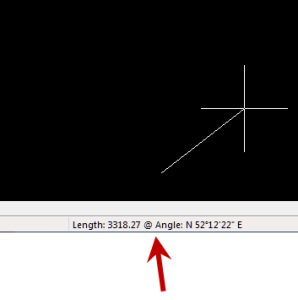
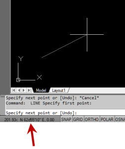
However, if you are currently in a command that requires two points be picked to specify an angle and distance (commands such as Line or Move, etc), you have a 3rd coordinate display available to you: polar coordinates. Unlike rectangular coordinates that display X, Y and Z position, polar coordinates report a distance and angle from the original point. For instance, when you start the Line command you can toggle the coordinate display so that rectangular coordinates are ON or OFF. But, after picking the first point of the line, you can toggle the coordinate display so that rectangular coordinates are ON, rectangular coordinates are OFF or that polar coordinates are ON.

The image below on the left shows the polar coordinate display in AutoCAD and the IntelliCAD version is shown below on the right:

IntelllliCAD Coordinate DisplayAutoCAD Coordinate Display


To toggle the coordinate display in newer versions of AutoCAD (since 2009?) double-click on the coordinate display. In older versions of AutoCAD and in IntelliCAD, the F6 button toggles the display.


BIM is not GIS

As someone quite entrenched in both disciplines (Civil and Architectural), I’ll add my 2 cents worth on the BIM vs. GIS subject.

In my opinion, BIM and GIS are both “methodologies” rather than “products”. The acronyms each have their own meaning and refer to designing, building, and managing information in a full life-cycle.

Each discipline has its own standards; from CAD standards to design standards (think of AIA vs. AASHTO), but both BIM and GIS rely on correct As-Built data to provide accurate information about their models.

BIM
The National BIM standard states the definition of BIM as:

BIM is best thought of as a digital representation of physical and functional characteristics of a facility…and a shared knowledge resource for information about a facility forming a reliable basis for decisions during its life-cycle; defined as existing from earliest conception to demolition.”

Autodesk has taken the BIM acronym that has provided a great deal of success with their Architectural Modelling packages and applied it to their Civil products as well. Their logic appears to be that its a “3D” product, therefore it is a “BIM” product. I believe that it is irresponsible to change terminology to simply advance product sales.

On the Autodesk Web Site, Autodesk lists a number of products as being “BIM” products:

  • Revit
  • Navisworks
  • Design Review
  • AutoCAD LT
  • + several more

With the acronym meaning Building Information Modelling (with building being a verb OR a noun), its interesting to see products such as AutoCAD LT and Design Review being shown on the list.

Revit
Revit is a Design Tool that allows the storage of certain pieces of information as well as the ability to add custom fields (heating capacity, cooling capacity, etc.) to the actual objects.

Navisworks
Navisworks integrates information from multiple data sources to provide a cohesive collection of information (graphics and data) to analyze things such as clash detection (HVAC duct work clashing with structural components, etc.).

AutoCAD LT
AutoCAD LT is Autodesk’s low-end design package. Apparently, any DWG file creation tool is now a BIM product as well.

Design Review
Design Review is a light-weight DWF viewer and markup tool. While it has been used as a backbone of products such as FMDesktop, its neither a Design tool, nor a Modelling tool.

FMDesktop
Absent from the list is FMDesktop. FMDesktop was one of Autodesk’s tools for managing the Building Information and Autodesk just dropped the product (Note: There are dozens of Facilities Managent Products available that provide similar capabilities such as FM:Systems, Archibus, Tririga, Manhattan, Cadapult, Famis, and more).

In the 2006 – 2007 time frame (when Autodesk acquired FMDesktop), Autodesk themselves showed customers Power Point slides regarding BIM. These slides showed where the “Design”, “Build”, and then “Operate and Manage” processes were performed. FMDesktop was Autodesk’s solution to tell the story of the building lifecycle and where the information was to be managed. These were broken down into 2 sections: The “Data Collection” piece and the FMDesktop piece.

Data Collection incorporated the Design (several disciplines such as Architects, MEP Systems Engineers, and Structural Engineers) as well as the majority of the Build process. The FMDesktop piece overlapped the Build process and then took over for the “Operate and Manage” process.

In my opinion, building that model of information AND managing that information is the true test of a “BIM” solution. There is no 1 product that is a “BIM” product. Its a series of technologies that are incorporated to provide the “information”.

Ultimately, a database component is required to work with the graphical representation of data (which certainly could be referred to as the “Building Model”).

GIS
GIS is BIM’s counterpart whereby Geographic (position on the planet) information is being stored and managed.

Most end users might think of GIS solutions as Google Maps or Google Earth where they can enter an address and out pops a graphic representation of that location or directions on how to get there. The graphic is just the tip of the iceberg. Without the data, the graphic would simply be a pretty picture.

Just as with BIM data, GIS data utilizes design tools to build the graphics and As-Built data and then tools to expand upon the As-Built information.

While there are a number of individual products on the market to assist in the creation, manipulation and distribution of GIS data, a complete GIS system involves more than 1 product or techonology.

A couple of the common Design Products are: Autodesk Civil 3D and Carlson Civil Suite

AutoCAD Civil 3D
Civil 3D is an object-oriented design tool for Civil Engineering applications. Because the tool is object oriented, the end product is not easily distributable. The data can be transferred to other links in the GIS solution chain by using technologies such as LandXML, but the graphical interaction is lost in this process (i.e. the objects are lost).

Carlson Civil Suite
Carlson’s Civil products work with DWG files in an AutoCAD or IntelliCAD DWG format. Because the data is stored as compatible DWG information with external data files, the data is easily transferred to other products in the GIS solution chain.

Managing the data developed in the design process is the next component of the GIS life-cycle. A number of products provide those solutions: ESRI ArcGIS, Vueworks, and Custom Mapguide Solutions.

ESRI ArcGIS
ESRI’s shp (shape) and adn (coverage) files are quite possibly the most prevalent GIS specific data files available and are often integrated in GIS solutions. ArcGIS allows GIS solutions to be deployed similar to FM solutions in the BIM world.

Vueworks
Vueworks is an organization that builds GIS and Work Management solutions using the ESRI base applications.

MapGuide
MapGuide is Autodesk’s development environment to build GIS applications. It is often used in concert with ESRI, Microstation and Autodesk data files.

GIS Standard
While there is not yet a concensus on a singular GIS standard, there are independent Spatial Data Standards employed by each digester of GIS data. You can view some of those here:

Both GIS and BIM perform very specific functions in accordance with their own disciplines. While the terminology is often mis-used, they refer to unique information systems; BIM in the structural facility world and GIS in the geographic world.

Originally posted on Carlson Connection by Jon Luby