Carlson Software Training – New and Improved in 2014

With the new year upon us I’m announcing some exciting new changes to my training policy and offerings…

First, the bad news: My hourly rates for custom online training will be going up on January 1. If you’ve already scheduled training at the old rate, this doesn’t apply to you. Email me to request new rates.

Second, the good news: Anyone who purchases software from me will receive discounted training rates. Like I said, email me to request the new rates.

Third, the great news: Starting January 15th I will be conducting a series of monthly webinars that you’ll be eligible to attend if you purchased software from me in the preceding 12 months. These 1-2 hour sessions are something new I’m trying for 2014 as a way to provide my customers between 18 and 24 hours of training over 12 months.

In January, March and other odd-numbered months, we will spend approximately 2-hours introducing you to Carlson Software. These will be repeat sessions meant to accommodate new users coming on through the year. These sessions will cover settings & setup (using the IntelliCAD/for AutoCAD version), importing points, overview of Field to Finish, surface creation, deed entry and annotation, centerline definition and stationing and creating profiles. There will be time for questions at the end.

In February, April and other even-numbered months, we will hold 1-2 hour training sessions on other, specific features in Carlson Software. Some topics we have planned are for survey traverse adjustment, surface modeling and drafting of pipes and structures in hydrology. These sessions will also be interactive and you’ll have an opportunity to ask questions.


The fine print: There will be a limited number of “seats” available for the sessions (limits of the technology). If we start bumping up against the limit of attendees, only one person per company will be able to attend each session. If we have plenty of seats available, that won’t be an issue.

You can pre-register for the January, February and March 2014 events here

The topics, date and time for future sessions will be posted later. After pre-registering, we will confirm your recent purchase and, if you are eligible to attend, I will send you the meeting login information.


Did You Know… About Carlson’s Export to KMZ (Google Earth) Command?

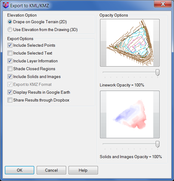
Carlson Software gives you the ability to export drawing entities directly to the Google Earth application or, alternatively, to a .kml or .kmz file that can be opened in Google Earth. At this time Carlson supports the export of points, polylines, text, solids, images, lines and arcs to Google Earth or .kml/.kmz files.

In Carlson 2014 they have also included the option of sending the Google Earth file directly to a Dropbox account for sharing with clients or other project team members.

The Export to Google Earth command is found in the File menu in all Carlson desktop programs.

Export to KMZ file


End of Year Workshops – New format for 2013

After several years of the same format for our end of year workshops, we’ve changed it up a bit this year.

For the first time, we will have one full day in both Statesville and Raleigh NC dedicated to Surveying and GIS topics and an additional day focusing on Civil and Hydrology topics. Each day will also include a unique presentation of the popular CAD Tips & Tricks session that, hopefully, sends everyone home with something they can use the next day.

In addition, we’re conducting 1/2-day events in Wilmington and Hendersonville (Asheville area) covering a variety of topics.

Each full-day class will give NC licensed surveyors and engineers 8 PDH credits and the 1/2 day events are eligible for 4 PDH credits. All events include lunch, software pricing specials and giveaways.

November 11th, Hendersonville NC – $49 for 4 PDH credits
Download Hendersonville (Asheville) Announcement Here
Register for Hendersonville (Asheville) Workshop Here

November 12th, Survey & GIS Workshop, Statesville NC – $99 for 8 PDH credits
Download Statesville Survey/GIS Announcement Here
Register for Statesville Survey/GIS Workshop Here

November 13th, Civil & Hydrology Workshop, Statesville NC – $99 for 8 PDH credits
Download Statesville Civil/Hydro Announcement Here
Register for Statesville Civil/Hydro Workshop Here

December 9th, Wilmington NC – $49 for 4 PDH credits
Download Wilmington Announcement Here
Register for Wilmington Workshop Here

December 11th, Survey & GIS Workshop, Raleigh NC – $99 for 8 PDH credits
($89 registration thru 10/31/2013)
Download Raleigh Survey/GIS Announcement Here
Register for Raleigh Survey/GIS Workshop Here

December 12th, Civil & Hydrology Workshop, Raleigh NC – $99 for 8 PDH credits
($89 registration thru 10/31/2013)
Download Raleigh Civil/Hydro Announcement Here
Register for Raleigh Civil/Hydro Workshop Here


Job Opening in Raleigh-Durham area of NC

Greater Raleigh AE firm looking for CAD talent. C3D 2012 Drafter for machine modeling, site survey, construction and engineering projects.

Carlson experience is a plus and Microstation/Geopak a double plus. Our ideal candidate will be able to learn new software quickly, have a good understanding of survey mapping and site civil design. For consideration, Drafter must be willing to take the lead, work on computer all day, have a stellar attitude, able to pass drug screening and have a good driving record.

Please forward resume to [email protected] or fax to 919-297-0090


That CAD Girl Newsletter | September 2013

Click here for the September 2013 issue of my newsletter…


Carlson 2014 Has Been Released

Carlson released the 2014 version of their desktop products today. This includes: Civil Suite, Civil, Survey, Hydrology, GIS, Takeoff Suite, Construction, Point Cloud, Geology, Surface/Underground Mining and Natural Regrade.

The 2014 embedded-AutoCAD versions of Takeoff Suite and Survey have not yet been released.

Carlson Desktop products include IntelliCAD 7.2b and can run on top of full AutoCAD-based products versions 2004-2014. This includes AutoCAD, Map, Land Desktop and Civil 3d. Also, anyone using the FREE IntelliCAD that comes with Carlson is still eligible for a FREE GIS Starter Kit from Esri which includes ArcMap. [This offer ended on 12/31/2013]

You can download Carlson 2014 here.

View the “Survey and Civil – What’s new in 2014” webinar here

If you are using 2013 and are current on your annual maintenance contract, you can click here to look up your new 2014 serial number online. You will need to enter your contact information and your 2013 serial number in order to generate the 2014 serial number. You can find your serial number by opening Carlson Software and going to Help > About Carlson Software > Change Registration.

If you have trouble finding your serial number or would like to know the cost to upgrade any product to 2014, please email me with your request.

Click here for the full list of improvements in Carlson 2014


Sneak Preview – Mass Haul Analysis in Carlson 2014

Todd Carlson helped me out with a demonstration of Carlson Takeoff a couple months ago and the company we were presenting to was looking for some particular features in a mass haul analysis routine. They had looked at several other programs as well as Takeoff and had yet to find a solution to their particular issue.

Fast-forward about a month and Todd followed up to let us know that the new functionality had been incorporated into the software and would be available in Carlson Civil and Carlson Construction/Takeoff 2014. This is a perfect illustration of how responsive Carlson is to their customers (or even prospects, in this case).

I asked Todd to write up a little preview of the new Mass Haul Analysis routine we’ll see in Carlson 2014:

Mass Haul Analysis in a nutshell:
Mass Haul Analysis determines the volume and haul distance for groups of net cut and net fill station ranges along a road. The program calculates the optimized cut to fill movements so that the total volume-distance moved is minimized.

New Feature:
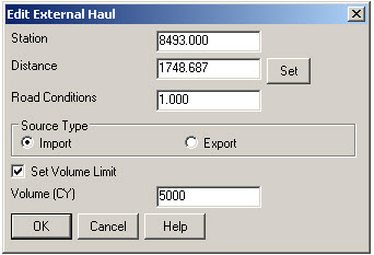
When dealing with multiple external hauls, users can now input the distance (and a “road conditions” factor) a borrow pit or dump pile is from its entry station. The program will then use this information when minimizing earth movement along the road.

For example, as shown in the first graphic below, an image of the area was inserted into the drawing from Google Earth or the Esri Mapping Service. CAD polylines were sketched along the travel paths from multiple pit locations to the project site.

Then, purely based off stationing, borrow pit (A) may be closer to a fill area than borrow pit (B). However, if the distance from borrow pit (B) to its entry station is closer than borrow pit (A)’s, the program may determine to use (B) as the borrow pit over (A) to optimize the earth movement.


Learn more about Carlson Civil and Carlson Takeoff


Carlson SurvCE 3.0 and SurvPC 3.0 Released

From Carlson’s website:

Featuring hundreds of additions and improvements, Carlson SurvCE 3.0 supports the widest range of popular and new release RTK GPS and conventional/robotic total stations of any other data collection software on the market.

SurvCE 3.0 has been released and is now ready for download. Constantly being upgraded, SurvCE features an optional icon-based interface and new Cloud-based messaging, file transfer, NGS monument recall, simplified stakeout methods and powerful GPS measurement averaging and blunder detection in the field (with accuracies in-between RTK and post-processing).

The Carlson SurvCE 3.0 upgrade is offered for just $150 for Carlson customers already using SurvCE 2.0 and above. The price to purchase SurvCE remains the same as it has since 2007.

Literally 100s of enhancements have been built into SurvCE 3.0.


Click here for SurvCE 3.0 Features

Click here for SurvCE 3.0 Screen Shots

Click here for SurvCE 3.0 System Requirements

Click here for SurvCE 3.0 Supported Hardware


Click here to purchase and also, sign up here for our newsletters to be notified of upcoming hardware and software special discounts!


Carlson Boot Camp Training in New Jersey – Approved for PDH Credit

I just received word from the NJ State Board of Professional Engineers & Land Surveyors that our Woodbridge classes will be accepted for continuing education credit. Our full list of upcoming classes in Columbus Ohio, Chicago Illinois and Upstate South Carolina can be found here.

Boot Camp! Carlson Survey & Field to Finish – April 10, 2012 – Woodbridge, NJ

Boot Camp! Surface Modeling – April 11, 2012 – Woodbridge, NJ


CAD Test – NC & SC Surveyors Edition!

Congratulations to Keith Garrison who won the software giveaway at the NC Surveyors Conference and to Xan Holland who won at the SC Education Conference and Trade Show.

We had a CAD Test with 25 questions for attendees to test their wits and the first person to get 100% or the high score won a free copy of Carlson Survey 2012 with IntelliCAD. Keith got a high score of 88% in Greensboro and Xan tied with Greg Flowe at 84% in Columbia. Xan and Greg went through two rounds of tie-breakers before Xan was declared the winner.

Look for our booth at the SC Engineering & Surveying Conference in June 2012 to test your CAD skills!