Year End Specials for Carlson Software

Updated 11/4/2013: I’ve just added several more end of year specials for Survey with IntelliCADTakeoff Suite, Construction, Trench, GeoTech, Survey with IntelliCAD and manuals and more… Remember to Add Coupon for best pricing!

Carlson jumped the gun a bit and announced their year-end specials today… Special pricing will end at noon on 12/31/2013. In addition, all software purchases through 12/31  include 2 hours of online training.

Check out my online store and make sure to pick the item’s “Add Coupon” button for best pricing:

Carlson Civil Suite including one year of upgrades/maintenance

Carlson Survey 2014 with embedded AutoCAD


Carlson CADNet 2014 including one year of upgrades/maintenance

CADNet is a new module for 2014 – broken out of Takeoff. CADNet has tools for digitizing, importing raster and vector data from images and PDFs, merging two image files, BIM data and more. Check out this recent webinar introducing Carlson CADNet to see how powerful it is.


Register for Carlson’s “What’s New in 2014” Webinar Series

As we’re all getting ready for the release of Carlson’s 2014 desktop products, Carlson Software has scheduled a series of 5 lunchtime webinars to introduce new features and enhancements. See below for details and registration links:

Carlson Survey and Civil 2014
Wednesday, July 24th – presented by Scott Griffin, Director of Sales

Carlson Construction 2014
Wednesday, July 31st – presented by Todd Carlson, Takeoff Product Manager

Carlson Hydrology 2014 and all new Carlson Trench
Wednesday, August 7th – Mark Long, Developer, & Todd Carlson

Carlson Mining 2014
Wednesday, August 14th – Grant Wenker, Director, Mining Division

All new CADnet
Wednesday, August 21st – Jim Carlson, Regional Sales Director

All new GeoTech
Wednesday, August 28th – Dave Sanford, Regional Sales Director


Sneak Preview – Mass Haul Analysis in Carlson 2014

Todd Carlson helped me out with a demonstration of Carlson Takeoff a couple months ago and the company we were presenting to was looking for some particular features in a mass haul analysis routine. They had looked at several other programs as well as Takeoff and had yet to find a solution to their particular issue.

Fast-forward about a month and Todd followed up to let us know that the new functionality had been incorporated into the software and would be available in Carlson Civil and Carlson Construction/Takeoff 2014. This is a perfect illustration of how responsive Carlson is to their customers (or even prospects, in this case).

I asked Todd to write up a little preview of the new Mass Haul Analysis routine we’ll see in Carlson 2014:

Mass Haul Analysis in a nutshell:
Mass Haul Analysis determines the volume and haul distance for groups of net cut and net fill station ranges along a road. The program calculates the optimized cut to fill movements so that the total volume-distance moved is minimized.

New Feature:
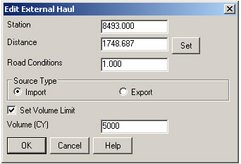
When dealing with multiple external hauls, users can now input the distance (and a “road conditions” factor) a borrow pit or dump pile is from its entry station. The program will then use this information when minimizing earth movement along the road.

For example, as shown in the first graphic below, an image of the area was inserted into the drawing from Google Earth or the Esri Mapping Service. CAD polylines were sketched along the travel paths from multiple pit locations to the project site.

Then, purely based off stationing, borrow pit (A) may be closer to a fill area than borrow pit (B). However, if the distance from borrow pit (B) to its entry station is closer than borrow pit (A)’s, the program may determine to use (B) as the borrow pit over (A) to optimize the earth movement.


Learn more about Carlson Civil and Carlson Takeoff


Carlson Software End of Year Specials

Last week Carlson announced their end-of-year specials for 2012. This year’s offerings include steep discounts on Carlson Civil Suite, Survey with embedded AutoCAD, Takeoff and Survey.

All discounts will end at noon on 12/31/2012.


As with all of my pricing, I’m prohibited from advertising my actual lowest prices so call or email for Coupon Codes for further discounts.

$2,795 for Carlson Civil Suite (includes one year of maintenance) – Retail price is $3,954.50

$2,295 for Carlson Survey 2013 with embedded AutoCAD – Retail price is $2,995

$5,000 for Carlson Takeoff 2013 with IntelliCAD – Retail price is $9,000

$6,500 for Carlson Takeoff T6 (2013) with embedded AutoCAD – Retail price is $9,000

$875 for Carlson Survey 2013 with IntelliCAD and one-year Maintenance for anyone who already owns SurvCE, Fast Survey or Triton. A valid serial number is required prior to purchase. Retail price is $1,754.50.


Carlson Software Self-Study Manuals

In order to reduce the amount of time I’ve been spending in online training, I’d been considering putting together Carlson Software training manuals. But, in order to truly offset the majority of the training I do, the first book had to be more than a standard software training manual that covers a broad range of topics.

So, I’ve just completed and started shipping the first 2 books that I’m calling Self-Study Manuals. They will be a great substitute for training for beginning users of Carlson Software and also as “fill-in-the-blanks” training for more experienced users. The lessons are very detailed, down to every pick and click. You do not even need to know AutoCAD or IntelliCAD to complete them. I think you will find them very beneficial if you’re new to Carlson or even to help bring your field crew up to speed as office help.

At this time, there are 3 lessons available: Carlson Configuration and CAD Settings (about 0.5 hours of instruction), Getting Started with Points for Survey or Civil (about 4.5 hours of instruction) and Field to Finish (about 6.5 hours of instruction). I’ve combined the Carlson Configuration and CAD Settings and Getting Started with Points for Survey or Civil into the first book and the Field to Finish is a separate book. Additional books are on the way… some will be detailed, self-study manuals and others won’t. I will be focusing on the ones that most closely follow the demand for training.

The books can be purchased separately or as a bundle from my online store. Introductory pricing is available through the end of 2012.

View a sample of the Getting Started with Point Self-Study Manual here

View a sample of the Field to Finish Self-Study Manual here


Carlson Configuration and Settings

Approximately 0.5 hours of instruction

When first launching Carlson Software, you can make changes to the configuration and options that will apply to the current and future drawing sessions. Some of the settings and options are specific to Carlson Software and some are specific to AutoCAD® or IntelliCAD®.

Part 1 of this lesson contains Carlson Software‐specific settings and is applicable to anyone using Carlson with either an AutoCAD or IntelliCAD platform.

Part 2 contains AutoCAD‐specific settings.

Part 3 contains IntelliCAD‐specific settings.

Appendix A explains how to use the Project Folder method of Project/Data File Setup as an alternative to the Drawing Folder method.

Appendix B explains the use of Carlson Quick Keys and how they interact with AutoCAD and IntelliCAD command Aliases.


Carlson Survey  Getting Started with Points

Approximately 4.5 hours of instruction

This lesson starts by loading a configuration file with recommended settings and options for the program. We will also open a few toolbars that may be needed for the exercises.

We will then start a new project and new drawing from a text/ascii file and will draw the points with the Draw‐Locate Points command. Various point editing and reporting commands and features will be used. Some of these features include: Point Groups, Tag Non‐Surface Points, Translate Points and Rotate Points. In wrapping up Part 1, we will export points to a new text/ascii file and also export the point data to a LandXML (.xml) file. Please note that Carlson’s Field to Finish is covered in a separate lesson.

Appendix A covers, as a separate exercise, the new Esri‐powered command Search Published Control that allows you to search published control data that is freely available on the National Geodetic Survey (NGS) website and then store the retrieved information to the active Coordinate File.

Appendix B provides a separate, in‐depth, explanation of the Carlson Point Block entity and how its Symbols and Point Attributes (Point Number, Elevation and Description) are controlled with respect to Layers.


Carlson Field to Finish

Approximately 6.5 hours of instruction

This lesson starts by loading a configuration file that contains recommended settings and options for the program. We will also open a few toolbars that may be needed for the exercises.

Part 1 provides an overview of the Field to Finish feature of Carlson® Survey. We will start a new project and new drawing from a text/ascii file. The text file is very similar to the one used in Lesson 2a – Getting Started with Points except that it has been slightly modified to include special linework coding. We will use Field to Finish so that the points, symbols and linework are automatically generated and drawn on their proper Layers. Field to Finish will also create Point Groups and tag some points as Non‐Surface so they can be easily excluded when we build a surface model.

In Part 2 we will create a new Field to Finish Code Table that includes a variety of Codes that can be used to create Symbols, 3d and 2d Linework.

In Part 3 we will simulate collecting more than 70 survey points in the field and then processing them with the Field to Finish Code Table created in Part 2. With this Code Table, we will collect points for features such as roadways, buildings, trees and property corners. We will also demonstrate the use of Special Codes for labeling descriptive information such as ½” Iron Pipe
and 12” Oak Tree.

In Part 4 we will use the Separate Attribute Layers functionality within Field to Finish so that Symbols and Descriptions for points we process can be used to label features on printed plans.

In Part 5 we will go through the steps required take some of your existing point files to make a new Field to Finish Code Table for your company.



Carlson 2013 Has Been Released

Carlson released the 2013 version of their desktop products today. This includes: Civil Suite, Civil, Survey, Hydrology, GIS, Takeoff, Construction, Point Cloud, Geology, Surface/Underground Mining and Natural Regrade.

The 2013 embedded-AutoCAD versions of Takeoff and Survey have not yet been released.

Unlike previous versions of Carlson that support running on top of IntelliCAD or AutoCAD products 2000-2012, Carlson 2013 can only be run on IntelliCAD or AutoCAD products 2004-2013. This includes AutoCAD, Map, Land Desktop and Civil 3d. Also, anyone using the FREE IntelliCAD that comes with Carlson is eligible for a FREE GIS Starter Kit from Esri which includes ArcMap.

You can download Carlson 2013 here.

If you are using 2012 and are current on your annual maintenance contract, you can click here to look up your new 2013 serial number online. You will need to enter your contact information and your 2012 serial number in order to generate the 2013 serial number. You can find your serial number by opening Carlson Software and going to Help > About Carlson Software > Change Registration.

If you have trouble finding your serial number or would like to know the cost to upgrade to 2013, please email me with your request.

Click here for the full list of improvements to Carlson 2013

Click here for improvements to the General commands in 2013

Click here for the additional data file & conversion support in Carlson 2013

Click here for improvements to Survey commands in 2013

Click here for improvements to Civil commands in 2013

Click here for improvements to Hydrology commands in 2013

Click here for improvements to GIS commands in 2013

Click here for improvements to Takeoff commands in 2013

Click here for improvements to Point Cloud commands in 2013

Click here for improvements to Geology commands in 2013

Click here for improvements to Surface/Underground Mining commands in 2013

Click here for improvements to Natural Regrade commands in 2013


IntelliCAD Webinar – Do Over

Last week I presented a webinar sponsored by Carlson Software on the topic “Updates and Overview of IntelliCAD 7”. Unfortunately we had some technical difficulties and didn’t get a complete recording to post to the Movies collection on Carlson’s website.

For those who are interested, we will be re-doing the webinar on Thursday, March 29th. By that time we expect to have additional updates and improvements to announce.

Keep an eye on this site to register for the next IntelliCAD webinar

You can register for these future webinars by clicking the link below:


New Carlson Build – 120219

Carlson released a new build of their desktop software earlier this week. This includes updates to the IntelliCAD/for AutoCAD versions of Survey, Civil, Hydrology, GIS, Basic Mining, Geology, Underground Mining, Surface Mining, Natural Regrade, Field, Takeoff, Construction and Point Clouds.

To confirm your current build number, go to Help > About Carlson. You’ll see the build number on the top line of the text box.

You can download the latest full version or updates to your current installation here.

If you would like to try out any of the Carlson Software products for 30-days, email me here.

For those anxious to try out the very latest and greatest updates in the testing versions of IntelliCAD 7.1, you can also send me an email to gain access to a new blog, “The Little CAD Engine That Could”, administered by Leonid Entov of Carlson Software.

Participation in the testing and access to the blog is by invitation only, so email me and I’ll pass along your request.


Carlson 2012 Updates

You can download the most recent updates to Carlson’s 2012 desktop software HERE


End of Year Workshops – Statesville, Asheville, Wilmington and Raleigh NC

We are finally able to announce our end of year workshops for 2011. With the weather problems we encountered last year we decided to hold the events in the western end of North Carolina in November and toward the coast in December.

The cost to attend each event is $99 and lunch is included. See below for early bird registration details for each event. NC Licensed Surveyors and Engineers will receive 8 PDH credits and all attendees will receive a certificate confirming their attendance. We will have door prizes, software giveaways and special software or hardware pricing that is available the day of the show only.

We will be in Statesville on Tuesday, November 15th and Asheville on Thursday November 17th. Early bird registration is $89 through September 30th.

We will be in Wilmington on Tuesday, December 13th and Raleigh on Thursday December 15th. Early bird registration is $89 through October 31st.

You will be able to choose the sessions you wish to attend. This year’s sessions include:

  • GIS from A to Z and Responding to GIS-related RFPs
    presented by Janet Jackson (GIS Janet) of Intersect
  • Overview of Carlson Takeoff & Preparing Machine Control Data
    presented by Todd Carlson of Carlson Software
  • Intro to SurvNet & Least Squares
    presented by Donnie Stallings, the original developer of the product
  • CAD Standards Roundtable & Discussion
    presented by Jennifer DiBona, That CAD Girl
  • CAD Tips & Tricks and hints for sharing data with others
    presented by Jennifer DiBona, That CAD Girl
  • Overview of Carlson Software 2012 (Survey, Civil, Hydro, GIS, Point Clouds)
    presented by Scott Griffin of Carlson Software
  • Field to Finish with Carlson Survey & SurvCE and the Surveyor+ GPS System
    presented by Butch Herter of Carlson Software and Jeremy Taylor
  • Preview of future Carlson hardware
    presented by Butch Herter of Carlson Software and Jeremy Taylor
  • Road Design and Site Design with Carlson Civil & Hydrology
    presented by Scott Griffin of Carlson Software

Note that all classes are not scheduled at all events and locations. See each workshop announcement for specifics. Seats are limited so register online, call 919.417.8351 or email us to register.